


This article presents new data from fieldwork in the de facto state of Somaliland, a country in the Horn of Africa historically inhabited by nomadic pastoralists who played a key role in commercial exchange from the first century BCE onward. Relations between ancient empires and nomadic populations have received comparatively little attention in relation to other groups living within or outside imperial boundaries.
By Alfredo González-Ruibal, Jorge de Torres, Candela Martínez Barrio, Manuel Antonio Franco Fernández, Adolfo Fernández Fernández, Pablo Gutiérrez de León Juberías, José Yravedra Sainz de los Terreros, Michela Gaudiello, and Ahmed Jama Dualeh
The American Journal of Archaeology, Volume 126, Number 1 January 2022
SECTIONS
Abstract
This article presents new data from fieldwork in the de facto state of Somaliland, a region in the Horn of Africa historically inhabited by nomadic pastoralists who played a key role in commercial exchange from the first century BCE onward. Relations between ancient empires and nomadic populations have received comparatively little attention in relation to other groups living within or outside imperial boundaries. Our understanding of these interactions has been colored by stereotypes from classical authors and the elusive nature of their archaeological record. It is thus not surprising that the role of nomadic groups in long-distance trade networks in antiquity has been often downplayed. This is the case in the Western Indian Ocean region. Archaeological evidence from survey and excavation work conducted between 2018 and 2020 in Xiis and the Berbera area reveals the strong integration of the region in the Indian Ocean network, the high purchasing power of the nomads, and their heterogeneity. Participation in long-distance trade seems to have provoked important social changes in local communities that did not, however, put them on the path to sedentism and political centralization.1
Introduction
Nomads and Empire in Northeast Africa
Pastoralist communities were an important component of many empires in antiquity. They were not necessarily living in the margins or beyond imperial borders: semisedentary transhumant pastoralists have been documented archaeologically and epigraphically for the Roman period in southern France, Spain, and Italy and for the early Byzantine period in Anatolia.2 Yet compared to farmers, they have received relatively little attention. This is, even more, the case with nomads inhabiting the most arid regions of empires and their peripheries despite the prominent political, social, and economic roles they played vis à vis Rome, Parthia, and other imperial and state formations with which they had intense interactions. Nomadic societies were often deeply affected by the expansion of state economies, as they were entangled in imperial and world systems—such as the Western Indian Ocean network (fig. 1).3 In northern Africa, the Roman conquest led to important changes among pastoralists, within and beyond its borders, including an increase in interaction between settled and nomadic or seminomadic communities, a decrease in feuding, more restricted mobility, and the integration of herders into a market system through fairs and waged labor.4 In Egypt and Sudan, nomads variously identified in the sources as Saracens, Trogodytes, Blemmyes, and Beja participated in an increasingly complex transregional economy that comprised long-distance trade and mining.5 They do not seem to have had their mobility reduced with state expansion—if anything, the opposite—and in fact, some of them moved across provincial and imperial boundaries.6 At different times, nomads in Northeast Africa were co-opted as waged laborers (“external proletariat”),7 settlers, and border guards, but also feared as raiders and brigands.8 Thus, the Nobatai of the Western Desert were settled by Diocletian in the Dodekaschoinos to stop the attacks of another nomadic group, the Blemmyes from the Eastern Desert.9 In turn, the Aksumite kingdom fought against the Beja people of its western margins, but they also used them as troops, as it did with the Barbaroi of its eastern frontier.10

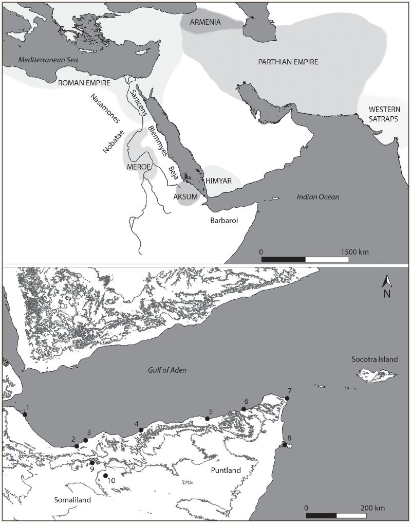
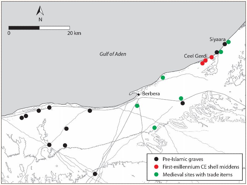
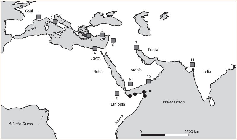
Fig. 1. Maps showing the area of study: top, map of Northeast Africa and the Western Indian Ocean ca. 300 CE showing major state actors (all capital letters) and nomadic groups (initial capital); bottom, map of the study area in the northern Somali coast showing places mentioned in the text: 1, Zeila; 2, Berbera; 3, Siyaara; 4, Xiis; 5, Ceelayo; 6, Qandala; 7, Daamo; 8, Ras Hafun; 9, Gugux; 10, Yiroowe.
From an archaeological point of view, much attention has been devoted to the origins of pastoralism in Northeast Africa, but our knowledge for the first millennia BCE and CE remains less than satisfactory, despite this being a crucial period in which nomadic pastoralism as we know it probably developed for the first time.11 Highly specialized forms of nomadism became possible in complex state systems that fostered interactions between different groups exploiting specific ecological or economic niches. It is thus not surprising that archaeological evidence of relations between pastoralists and sedentary communities became common throughout the first millennium CE in Northeast Africa. From the Egyptian Eastern Desert to the Sudanese Gezira, graves of mobile or semi-mobile pastoralists have produced imported materials that attest to these pastoralists’ engagement in long-distance networks and their high purchasing power, either because of their role as intermediaries or as purveyors of key resources.12 This involvement was not without sociopolitical and cultural consequences, whose reach we cannot yet fathom. Few pastoralists benefited more from their insertion in expansive commercial networks than those of the Somali coastland. They are the subject of the present article. Here we present new data coming from surveys and excavations conducted in sites of the first millennium CE in the de facto state of Somaliland between 2018 and 2020. Archaeological evidence provides a glimpse of the complexity, dynamism, and heterogeneity of nomadic communities in Northeast Africa and their crucial role in the global economies of the ancient world.
The Indian Ocean System and the Far-Side Ports
Like their counterparts in Sudan and Egypt, the nomadic communities of the Horn of Africa were involved in long-distance trade in antiquity. However, in this case, we are referring to the most complex and far-reaching commercial network of the ancient world, one that had ramifications from northwest Europe to China: the Indian Ocean system. While connections throughout this ocean region existed from prehistoric times, what we could call a world-system came into being around the end of the first century BCE and developed throughout the first millennium CE, during a period dominated by a few large state polities: the Roman and Byzantine empires, the kingdoms of Meroe and Aksum in Northeast Africa, the kingdom of Himyar in South Arabia, the Parthian and Sassanian empires in the Middle East, and the Middle kingdoms and the Gupta empire in India.13 The system was fully established and operational by the mid-first century CE and remained so, despite various crises, until European colonization in the late 19th century. The system allowed for the movement of goods, ideas, and people across enormous distances, bringing together radically different cultures and social systems. This gave rise to the emergence of cosmopolitan societies, hybrid groups, and diasporic communities.14 As is the case with other commercial networks, the role of nomads and stateless peoples more generally has been largely overlooked.
The relevance of the Horn of Africa, however, should not be underestimated. It was located in a key strategic position, a chokepoint between the Indian Ocean and the Red Sea, and it had extremely valuable resources, including incense and ivory. The northern Somali seaboard, in fact, features in the Periplus Maris Erythraei, the main source of information for the Early Roman Western Indian Ocean trade.15 In that manuscript, written by an anonymous sailor who was well acquainted with the Indian Ocean routes during the mid-first century CE, the ports of the Somali coast are grouped together under the label of “far-side ports” and include Avalites (usually identified with Zeila), Malaô (Berbera), Mundu (Xiis), Mosyllon, Arômatôn Emporion, or “Spice Market” (Daamo), and Ôpône (Ras Hafun). Archaeological evidence in Somaliland from the time of the Periplus has been known since the 1880s when the French traveler Georges Révoil recovered in Xiis (Heis) a collection of Roman glass dated to the first or second century CE.16 These finds were a unicum in the Horn of Africa until the 1970s when Chittick found two other sites in the nearby region of Puntland (Somalia): Daamo and Ras Hafun, south of Cape Guardafui.17 The latter is the only one to have been excavated and the materials published in detail. Two areas of Ras Hafun were documented, one of which (Hafun West) furnished an assemblage of imported pottery dating from the first century BCE to the third century CE and the other (Hafun Main), dating from the second to the fifth century CE. The assemblage comprised, among other materials, Roman amphoras, glazed Parthian-Sassanian pottery, and Indian wares. At Hafun Main, a cairn necropolis was found and one of the tombs excavated, yielding a Mesopotamian glazed jar dated to around the third to fifth centuries CE.18 Some 250 km south of Hafun, in the Nugaal river mouth, a rock shelter was excavated; the upper levels yielded handmade pottery and a sherd of a wheelmade pot, likely ancient.19 There are no references to ports of trade in this area in the ancient sources. Farther south, no ports of trade have been found. Roman finds are known, however, including a coin of Alexander Severus in Mogadishu and a suspicious coin hoard including Hellenistic and Roman coins in Buur Gabo.20
Project Methods
Archaeological research on Western Indian Ocean trade from antiquity to postmedieval times has overwhelmingly focused on state societies and urban centers.21 Yet nomads played an important role in wide areas across Northeast Africa. Since 2015, research work has been conducted trying to redress the imbalance by studying the involvement of the communities of Somaliland in long-distance trade networks in ancient, medieval, and postmedieval times.22 Somaliland is a de facto state that declared independence from Somalia in 1991. Along with the autonomous state of Puntland, it occupies the northern Somali seaboard, which is the easternmost African region from which clear evidence of sustained commercial interactions in antiquity has been found so far.23
Our project drew on recent research in the area undertaken by the staff of the Department of Archaeology of Somaliland.24 They inventoried many sites from a diversity of periods and produced the first archaeological map of the country, but those sites with incontrovertible evidence of ancient long-distance trade remained basically the same as those described by Georges Révoil in the 1880s and Neville Chittick in the 1970s25—that is, the large cemeteries of Xiis and environs. Our intention was to conduct fieldwork here for several field seasons to better assess the region’s role in the Indian Ocean network. However, cyclone Pawan in late 2019 and the COVID-19 pandemic of 2020 interrupted our research after two campaigns. We thus decided to resume work in the Berbera region, which we knew well, with the aim of comparing two regions that had played important roles in long-distance interactions according to classical sources: Malaô and Mundu.
Work in Xiis in 2018 and 2019 consisted of an extensive survey of the coastal plain to identify all potential archaeological sites in Xiis itself and its surroundings. At the main site, an intensive survey with total coverage of the terrain was conducted: all structures (more than 300) were described in detail, inventoried, and recorded with a GPS, and materials associated with the cairns was collected, when available. Surface materials and structures not associated with specific tombs were also documented individually and mapped. These included scatters on the islet of Xiis and on Ma’ajilayn Hill, which overlooks the main cemetery (fig. 2). A detailed topographic map was produced using an unmanned aerial vehicle (UAV). In 2019, four tombs were selected for excavation. They were excavated in full following the stratigraphic sequence, and each layer was documented photogrammetrically. Osteological analyses were conducted in situ and at the museum of the Department of Archaeology in Hargeisa by physical anthropologist Candela Martínez Barrio, to determine age, size, sex, and any pathologies. Bone samples were collected for isotopic, DNA, and radiocarbon analyses, with no positive results, as the samples did not have any collagen left.
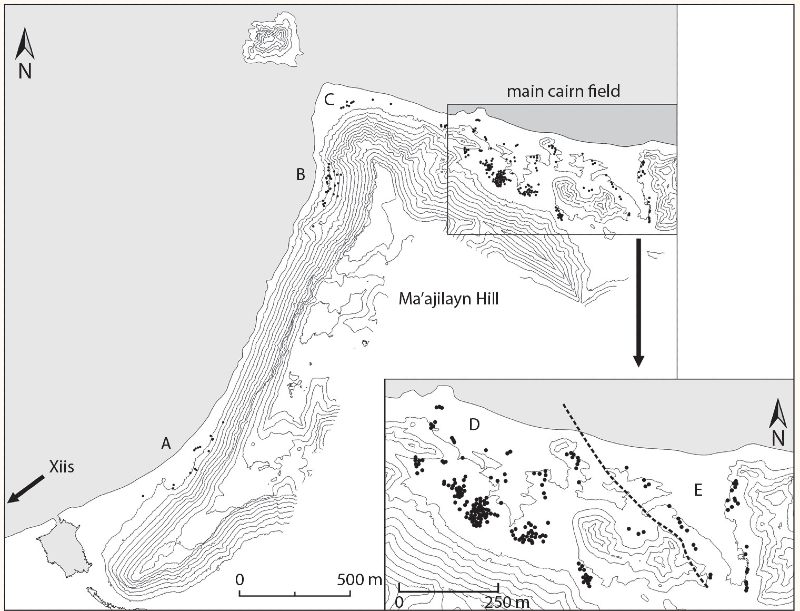
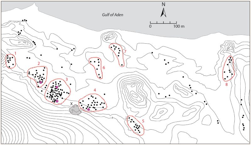
Fig. 2. General map of Xiis and inset detail of main site, with zone letters A–E.
The region of Berbera lies some 210 km along the coast west of Xiis. We first surveyed the area between 2015 and 2017 and discovered many sites from a variety of periods, some as early as the Neolithic to some as late as the late 19th century—but none from the first millennium CE. In 2020, we explored new areas and revisited some of the sites to try to find evidence of occupation related to long-distance trade in antiquity. We also carried out extensive surveys of the hinterland of Berbera as far as Burao, some 116 km from the coast as the crow flies, in which we located several pre-Islamic necropoleis. Those sites in the Berbera region that yielded evidence of long-distance trade were surveyed intensively, sampled, and mapped in detail.
Faunal remains were exported to the Complutense University of Madrid for analysis by zooarchaeologist José Yravedra. A large sample of imported artifacts from the 2018 survey at Xiis were sent to the University of Vigo, where they were studied by Roman pottery expert Adolfo Fernández. All other artifacts—including all of those from the 2020 field season—were catalogued, drawn, and photographed in Somaliland. All materials are deposited at the Museum of the Department of Archaeology of Somaliland, in Hargeisa. In what follows, we present a summary of the finds and interpret the data in the wider context of the Western Indian Ocean system.
XIIS: Necropolis and Port of Trade
The Periplus Maris Erythraei (9:4.1) refers to Mundu as a place “where vessels moor fairly safely at the island that lies very near the shore.” A small, rocky islet is indeed located 200 m off the shore at Xiis (see fig. 2). The entire landscape is dominated by a steep and rocky flat-topped hill, known as Ma’ajilayn, which rises 145 m above sea level. As noted above, the necropolis of Xiis has been known since the late 19th century, but no systematic research was conducted there until 2017 when Carl Phillips carried out a brief survey of the site for a construction company planning a new road and harbor in the area.26 He gathered a selection of artifacts that amplified Révoil’s collection and that coincided with those we documented a few months later, in a preliminary survey carried out in February 2018, and in a more systematic survey and excavations the following year.27 The objectives were to obtain a detailed map of the site, find nonfunerary activity areas, refine the chronology, and gather more archaeological evidence in context to determine the importance of long-distance trade at Xiis.
Survey of Xiis: Tomb Clusters and Tomb Typology
Our survey identified 296 graves of different shapes and dimensions, distributed in five zones: two west of Ma’ajilayn Hill (see fig. 2, A and B), two to the northeast (D and E), and one in front of the islet (C). The densest concentration of graves is located in the northeast, which is where work focused. More cairns can be found both east and west of the main Xiis necropolis, including a funerary site called Shalaw, where a stele with a Sabaean inscription was discovered.28 The tombs in the main site at Xiis appear both in clusters and linear arrangements and are of two types: circular and square. Circular tombs represent 78% of the total; 18% are square structures, and the remaining 4% are indeterminate, but most likely circular. So far, only individual graves have been found in excavation, both in circular and square cairns. Square tombs (online fig. 1)29 have not been excavated so far in Xiis, although Chittick dug one dated to the third to fifth centuries CE at the Ras Hafun Main site in 1976, which he named Hafun MS A but did not publish (fig. 3).30 Square tombs in Xiis are usually 7–8 m to aside. The outer perimeter is festooned with black volcanic stones, and the cairn fill is made with sandstone or coral rubble. On seven of the 39 square tombs, there were between two and 12 stelae, whereas only one round tomb had stelae. There is a tradition of raising baetyls in South Arabia and it is possible that Xiis’ standing stones are a manifestation of a South Arabian influence. Square tombs are known elsewhere in Puntland,31 Somalia, and Kenya, and they have sometimes been described as “rectilinear cairns.”32

Circular tombs vary in size between 2.5 and 10 m in diameter. As with the square cairns, chromatic effects are achieved by using blocks of different types (volcanic, sandstone, coral). The blocks on the base are usually larger in order to secure the stone heap, and therefore the tombs can be considered of the “kerbed cairn” type.33 In the clusters with the densest concentration of graves (see below), 70% of the circular tombs are 7.5 m in diameter or less (fig. 4; online fig. 2). The most common sizes are 2–3 m (N = 24), 7–8 m (N = 19) and 4–5 m (N = 17). The small- to medium-sized tumuli in Xiis contrast with the larger sizes documented in Berbera (see below), where diameters over 10 m are more common. The height is between 2 and 3 m in the larger cases and 0.5 to 1 m for the smaller tombs.
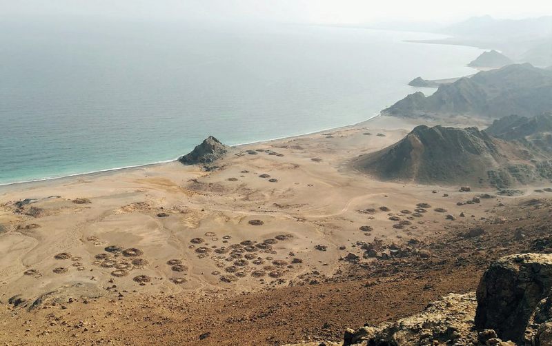
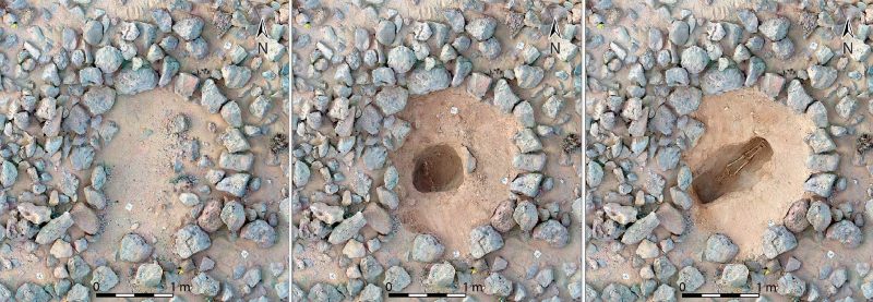
In most cases the cairns have a crater-like shape that was initially interpreted as looters’ pits, in accordance with the accounts by Révoil, Chittick, and the local community. However, a closer examination reveals that the lowest point of the supposed looters’ pit is often well above the ground level in which the burial was dug. Thus, the looters would have stopped before reaching the grave, which in most cases lies 1 m or more below the pit’s bottom. Furthermore, if the cairns were looted, there should be stones lying around, which is not often the case. Also, members of the local community know those grave goods are located at both ends of the burial pit and therefore tend to avoid the center, as we will see. It thus seems that the tombs were not fully filled with stones and that the crater-like shape of the cairns has to do with the original structure. In this case, the graves would belong to the type defined as “doughnut-shaped” or “ring cairn,”34 which has been documented among diverse pastoralist communities throughout Northeast Africa. It is, however, unusual in Somalia, where it has only been documented in large numbers at Xiis, Ceelayo, and Qandala (see below, “Other Far-Side Ports”).
Circular and square cairns are largely complementary (fig. 5): the former appear to the west of the site (Zones A–D), the latter to the east (E). Square cairns are found in linear groupings, whereas circular ones prevail in clusters. This complementarity may have cultural, political, social (different clans or groups), or chronological causes or combinations thereof. There are three factors suggesting a chronological dimension. First, if the square cairn excavated in Ras Hafun is dated somewhere between the third and fifth centuries CE,35 then it is later than the circular tombs of Xiis for which there is datable evidence (first to third centuries CE; see below). Second, it can be observed that many square cairns have at their core a typical circular cairn, out of which grows the rectangular stone structure; it can thus be hypothesized that these latter monuments are an evolution of circular tombs. Third, horizontal stratigraphy is evident: the necropolis of Xiis seems to have spread from the foothills of Ma’ajilayn toward the sea, and square cairns are located closer to the coast and to the east and therefore farther away from the hill.
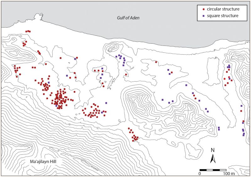
Regarding the distribution of the tombs, linear arrangements, mostly of square cairns, appear in the eastern part of the site (Zone E), flanking a small valley that opens up toward the sea. The arrangement, which creates a sort of funerary avenue, is typical of monumental tombs in Somaliland; it has been attested for the 11th to 14th centuries and probably occurs in other periods.36 The clusters consist of between 8 and 59 tombs in Zone D. The largest are Clusters 3 and 4, with 59 and 27 tombs, respectively (fig. 6). The density of graves is double in Cluster 3, as each grouping covers around 4,500 m2. There are also smaller clusters with two to four graves, which are perhaps later in date, as they lie outside the main concentrations of graves. Clusters 2–5 spread at the base of Ma’ajilayn Hill. Tomb groupings may represent clans or other sorts of corporate groups linked by kinship or affinity or both, but they seem to have a chronological dimension, too. This is suggested by the materials associated with the graves (see below, “Regional and Long-Distance Trade in Xiis”). Cluster 4 yielded the highest number of Roman amphoras, which can be dated to the first to second centuries CE, as well as the Italian terra sigillata, millefiori (mosiac glass), and ribbed glass, all dated to the first century CE (online fig. 3). In contrast, Cluster 3 produced no first-century CE imports, and the only burial with grave goods excavated here furnished a Roman glass flagon dated to the third century CE. All materials from Révoil’s collection come from Zone A and have been dated to the first to second centuries CE.37 In this case, they are fully coincidental with Cluster 4 and it can be safely assumed that two different corporate groups existed and used different spaces for burying their dead.
Excavation at Xiis
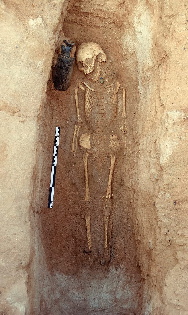
Four tombs were excavated in 2019, of which two were intact and two looted: one in Cluster 2, two in Cluster 3, and one in Cluster 4 (for full descriptions, see the appendix; for a summary of the data, see Table 1). Two of the tombs (49 and 120) held children; the other two (75 and 153), adults. Of the graves, one (75) had no grave goods and another (49; fig. 7) had perhaps only a Roman glass beaker and a shell pendant. The other two (120 and 153) had funerary assemblages that allowed the tombs to be dated through typological parallels. Tomb 120 (fig. 8) yielded a necklace with glass and iron beads, iron anklets, and, more importantly in terms of dating, a large glass flagon probably from Roman Syria dated to the third century CE. This appeared with the remains of a child (ca. 7.5–9.5 years old), probably a girl, as anklets and necklaces are historically an indication of female identity in the Horn of Africa. The Periplus Maris Erythraei (6) mentions the import of iron to the Somali coast and South Arabia (6, 10) and in one case refers specifically to its coming from India.
| Tomb No. | Max. Length (m) | Interment Orientation | Disturbed? | Age of the Interred (yrs.) | Sex of the Interred | Date | Grave Goods |
|---|---|---|---|---|---|---|---|
| 49 | 2.6 | SW–NE | yes | 5.5–6.5 | unknown | 1st–3rd c. CE? | scarce |
| 75 | 2.7 | NW–SE | no | 25–39 | male | unknown | none |
| 120 | 3.7 | E–W | no | 7.5–9.5 | female? | 3rd c. CE | some |
| 153 | 6 | N–S | yes | unknown | unknown | 1st c. BCE/CE | many |
Tomb 153 was the richest of the four but had been severely looted. Although only a few fragmentary bones appeared, the remains of the funerary offerings revealed an extremely rich burial: inside the tomb and on the surface were Mesopotamian glazed pottery, millefiori bowls, Roman monochrome glass vessels, decorated glass inlays, Egyptian fine ware, Italian terra sigillata, and abundant Roman amphoras (Dressel 2–4) and South Arabian Organic Storage Jars. The assemblage can be dated most likely to the first half of the first century CE. This is the only place where such a large amount of imported materials was found on the surface. This can be partly explained by the erosion to which this part of Cluster 4 has been subjected and some of the artifacts surely having come from neighboring graves, but some finds may also be associated with rituals and funerary banquets taking place around the tombs, as has been documented in late pre-Islamic contexts of the 12th to 14th centuries CE.38 Thus, while amphoras were deposited in the tombs, they also seem to have been discarded outside. Wherever the objects’ original deposition, the finds from Tombs 120 and 153 reveal the far-reaching long-distance contacts of these communities.
Other Activity Areas at Xiis
Apart from the tombs, three areas produced surface finds: the islet of Xiis, the hilltop of Ma’ajilayn, and a zone in the foothills adjacent to Cluster 4 to the southwest. On the hilltop, finds were less diverse than in the necropolis. There were remains of many South Arabian Organic Storage Jars and cooking pottery, but fewer glazed wares (15 sherds of turquoise-glazed pottery) and no other fine wares or glass. Traces of at least three rubble walls, one forming an angle that suggests the corner of a building, can be seen, but whether they can be associated with the finds or not is still unclear. The place was perhaps a temporary settlement area, with the advantage of having an extraordinary visual command over the sea and the shore. As for the islet (online fig. 4), there are some handmade plain wheelmade wares but few amphoras or fine wares, which suggests that the place was not used for unloading goods. It might have been a temporary settlement, perhaps for the merchants. Remains of low walls and terraces can be seen; they could have been used to adapt the irregular terrain to the pitching of tents or huts.
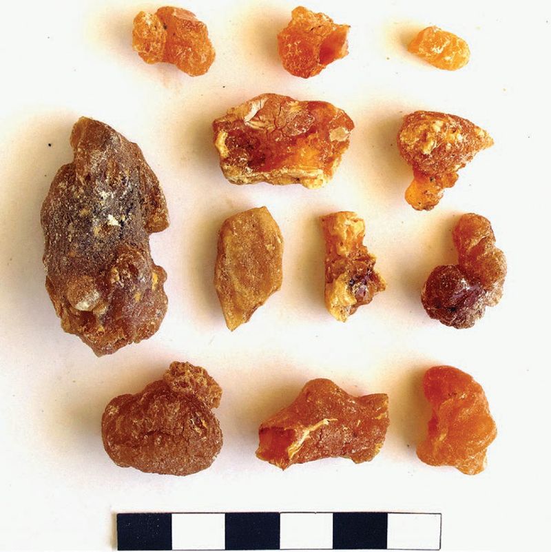
Finally, an area with boulders, small rock shelters, and outcrops between Cluster 4 and the base of Ma’ajilayn Hill yielded an important quantity of Roman amphoras, South Arabian Organic Storage Jars, and a few fragments of wheelmade kitchenware. Fine quality items were also recovered, including shards of various glass vessels, shards from two different millefiori dishes, and two fragments belonging to a single core-formed glass alabastron or aryballos in opaque blue with undulating yellow bands. Fine wares are represented by some sherds of green and turquoise Mesopotamian Glazed Ware. Among the amphoras there are two ostraka with Greek letters. On the larger sherd, which belongs to a Koan or Rhodian amphora, it is possible to make out the letters A, Y, and N (online fig. 5), and on the smaller, Δ and K. The presence of the ostraka makes it tempting to interpret the scatter as a merchants’ camp. However, local items were also found, including a fragment of a handmade finger-printed rim and three shell beads, two of them of Engina mendicaria, a sea snail with black and white stripes.39 Considering the proximity to the tombs, this could have been a meeting place between nomads and merchants. The most striking evidence for its possible use for commercial exchanges is several chunks of incense resin (fig. 9), whose significance will be explained below.
Regional and Long-Distance Trade in Xiis
The survey of the necropolis furnished a remarkable number of imported materials (Table 2).40 In fact, local pottery is virtually absent, with only half a dozen plain sherds on the islet and one in the necropolis, representing less than 1% of the entire assemblage. During the survey, 80 cairns yielded imported items, with Mesopotamian Glazed Ware being the most common (46 of the tombs), followed by glass of different types (N = 25), Roman amphoras (N = 19), and undecorated wheelmade wares (N = 15). Stone or glass beads appeared in seven cairns. Outside the necropolis—on the Ma’ajilayn hilltop and in the foothills—common finds included, as noted above, amphoras and large numbers of South Arabian Organic Storage Jars.
Table 2. Summary of imported materials (first to third centuries CE) found at Xiis by type and provenance.
| Category | Type | Provenance |
|---|---|---|
| amphora | Dressel 2–4 | Italy, Aegean |
| Gauloise 4 | southern France | |
| Agora M54 | southern Turkey | |
| AE3 | Egypt | |
| transport jar | Organic Storage Jar | South Arabia |
| fine ware | terra sigillata | Italy |
| Mesopotamian Glazed Ware | Persian Gulf, Mesopotamia | |
| Egyptian fine ware | Egypt | |
| glass | beaker | Italy |
| pillared bowl | Italy | |
| flagon | Syria/Cyprus | |
| inlays | Egypt | |
| millefiori bowl | Egypt | |
| bead | glass beads | Roman empire |
| Indo-Pacific glass beads | India | |
| stone beads (agate, carnelian, zeolite) | India | |
| anklet | iron anklets | India? |
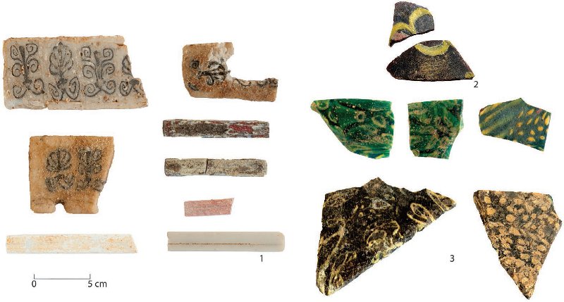
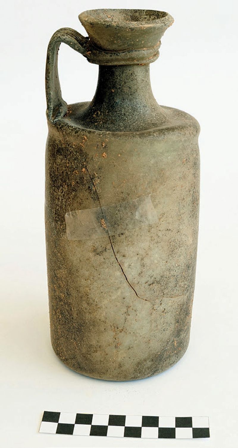
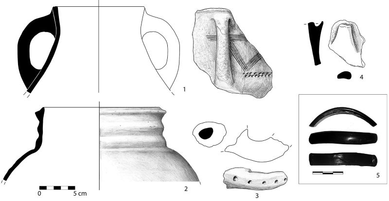
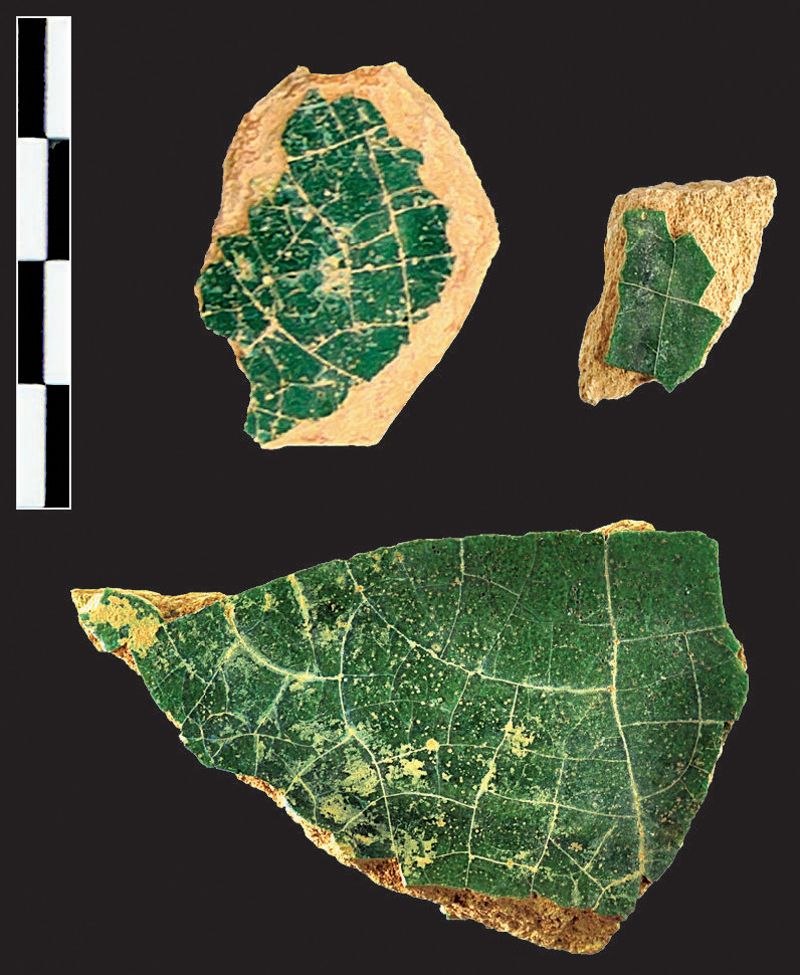
The study of the materials showed both similarities with and differences from Révoil’s collection, which is dominated by the high-quality glass including millefiori and inlays. The French explorer picked up fragments from at least 11 millefiori dishes and bowls, to which a minimum of four vessels from the latest fieldwork can be added. Inlays, plaques, and tiles are among the most remarkable finds from Xiis (fig. 10).41 They are variously decorated with palmettes, rosettes, feather patterns, floral motifs, and in one case a theater mask representing Dionysus. They were originally embedded in boxes made of ivory and perishable materials such as wood. Révoil found these inlays in Zone A, and we documented them in Zone E (Tomb 153, Cluster 4) (see fig. 6). They are identical and were surely produced in the same place, probably Alexandria, where, like the millefiori, they have some parallels.42 As for the palmette-decorated inlays, the best match comes from one of the royal tombs of Meroe, dated to the mid first century CE.43 Other glass finds include pillar-molded bowls in translucent blue-green glass, of which two were collected by Révoil44 and two others found in the latest fieldwork; they can be dated to the first half of the first century CE. In Tomb 120 a complete cylindrical flagon, which has characteristic handles with multiple combings, was found, dated to the third century CE (see figs. 8, 11). This luxurious piece, perhaps a perfume bottle, was likely produced in Syria or Cyprus45 and has some parallels in the royal graves of Aksum, which is indicative of its value.46
Révoil also collected a few sherds of terra sigillata and amphoras, but these represent a minor part of his documented assemblage. The new materials are coincidental in terms of chronology with those of the French explorer, but they are more varied. Clearly he focused on the most spectacular artifacts, not the most common, the aforementioned amphoras, South Arabian Organic Jars, and Mesopotamian Glazed Wares. The latter two are not even present in Révoil’s assemblage, and the first is greatly underrepresented, even if he surely encountered them in the field.
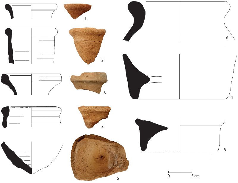
Among the amphoras, Dressel 2–4 prevail (Tables 3, 4). Most are from Italy, but there are also one Cilician and one Aegean Dressel 2–4. Other amphoras include Egyptian AE3 and Dressel 2–4 / AE4, Gauloise 4, and one Cilician Agora M54 (fig. 12).47 The other major category of containers is the South Arabian Organic Storage Jar. These have elongated, ovoid bodies and bases with high footings and thick walls. Four different fabrics have been documented, three of which, known from sites in South Arabia and India,48 contain abundant straw temper (thus the name of the vessel). A fourth one, with volcanic temper, has not been recorded so far elsewhere, but the inclusions point to Yemen or Oman, where basalt formations are common. Despite this difference, the overall aspect is very similar to the other organic jars.49 A small number of imported cooking wares were also recovered, which are characterized by coarse fabrics, gray core, and red-slipped surfaces. Their provenance is uncertain; it could be Egypt or the Persian Gulf.
Table 3. Diagnostic amphora sherds from the 2017 survey (Phillips 2018) and the 2018 Incipit-CSIC survey.
| Production | Type | Inclusions | Total No. of Sherds | Rims | Bases | Handles | MNI |
|---|---|---|---|---|---|---|---|
| Italian Campanian | Dressel 2–4 | black sand / grits | 10 | 5 | 3 | 2 | 5 |
| Italian | Dressel 2–4 | medium black inclusions | 3 | – | 1 | 2 | 1 |
| Gaulish | Gauloise 4 | – | 3 | 2 | – | 1 | 2 |
| Egyptian | Dressel 2–4 / AE4 | – | 3 | 3 | – | – | 3 |
| AE3 | – | 3 | 2 | – | 1 | 2 | |
| unclassifiable | – | 1 | 1 | – | – | 1 | |
| Cilician | Dressel 2–4 | – | 1 | 1 | – | – | 1 |
| Agora M54 | – | 1 | 1 | – | – | 1 | |
| Rhodian | Dressel 2–4 | – | 1 | 1 | – | – | 1 |
| Aegean | Dressel 2–4 | – | 1 | – | – | 1 | 1 |
| Total | 27 | 16 | 4 | 7 | 18 |
| Amphora Provenance | Total No. of Sherds | MNI | MNI % |
|---|---|---|---|
| Italy | 13 | 6 | 35 |
| Egypt | 7 | 6 | 35 |
| Eastern Mediterranean | 3 | 3 | 18 |
| Gaul | 3 | 2 | 12 |
| Total | 26 | 17 | 100 |
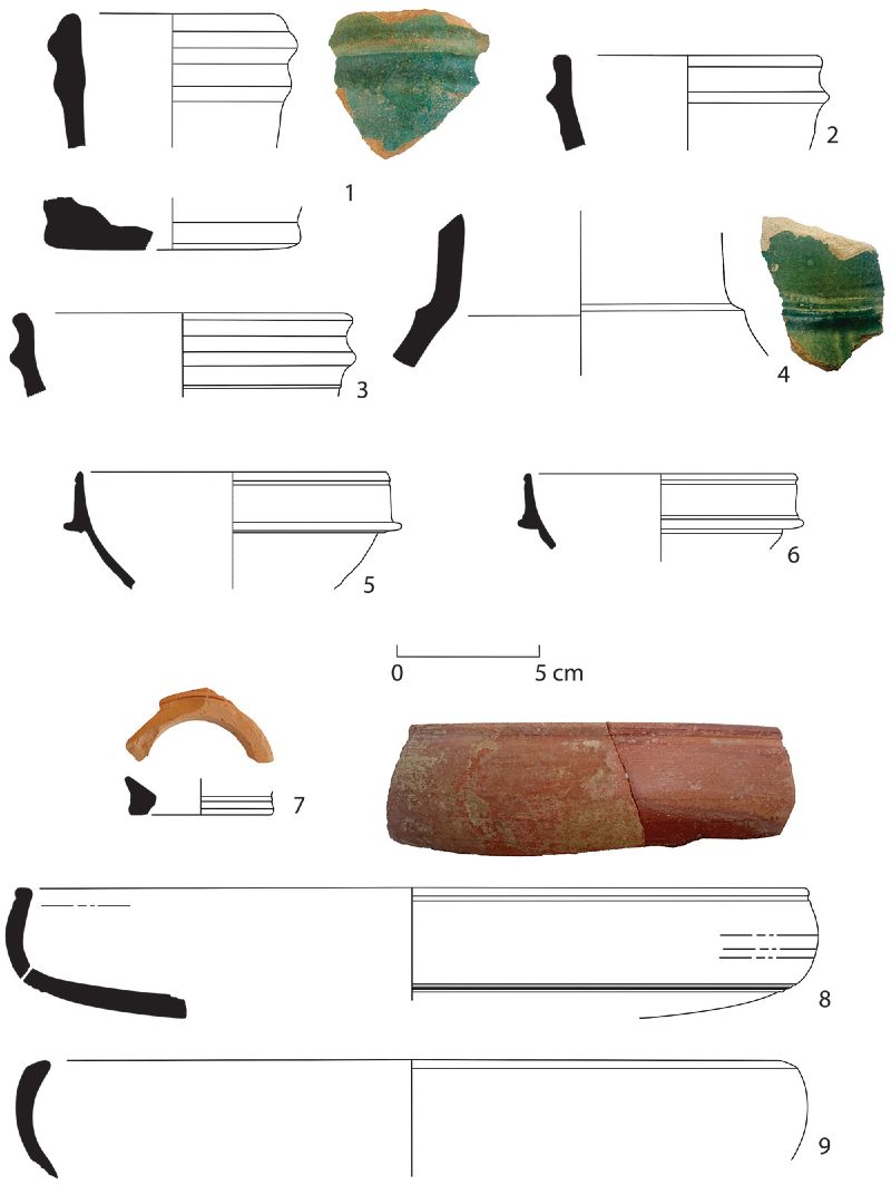
Fine wares found are terra sigillata, Egyptian fine ware, and the aforementioned Mesopotamian Glazed Ware (fig. 13). Italian terra sigillata and Eastern Sigillata A were already collected by Révoil in the tomb cluster identified as Zone A (near the village of Xiis).50 Two more examples of Italian terra sigillata were recovered in the looted Tomb 153 in Cluster 4,51 and survey yielded another fragment of Eastern Sigillata A in the foothills of Ma’ajilayn. Egyptian fine ware is represented by bowls and dishes similar to those found at sites like Myos Hormos and Berenike.52 Mesopotamian Glazed Ware is very common and is represented by small jugs and bottles, often with handles. The glaze is green, blue, turquoise, and beige, the last perhaps due to weathering. Turquoise- and blue-glazed vessels seem to have better levigated fabric.
Finally, a variety of beads exist in glass and stone—agate, carnelian, and a type of zeolite. Stone beads most probably came from India, where those minerals abound; trade in such beads with Africa is known from ancient to postmedieval times.53 Northeast African sources are known as well.54 As for glass beads, some were probably also imported from India, including tiny (0.2–0.8 cm) round beads in green, yellow, and blue that are very similar to so-called Indo-Pacific beads.55
Finds in Xiis show intense relations with the Roman empire, South Arabia, and the Parthian empire, and attenuated ties with India. Archaeology completes the picture provided by ancient sources, which emphasize, for obvious reasons, direct relations between the Mediterranean and the rest of the world, while other interactions that leave aside the Roman empire, such as between Arabia and Africa, are underrepresented.56 The importance of the Roman element in Xiis was further overemphasized by Révoil’s selective collecting. In contrast, the recent survey has shown that commodities from South Arabia and Parthia, represented by Mesopotamian Glazed Ware and South Arabian Organic Storage Jars, outnumber Roman imports in terms of volume, if not in terms of significance; it seems that the Roman empire was providing luxury goods in smaller quantities but with outsized value.
What were the locals exporting? If Xiis is identified with Mundu, then the nomads were providing three kinds of incense-like resins: myrrh, frankincense, and mokrutu, according to the Periplus Maris Erythraei (9). As we have seen, we have archaeological proof of the trade in aromatic resins near Cluster 4. The best-quality incense is known to be found from Xiis to the east,57 and the Daallo mountains, near Xiis, have three varieties of incense-yielding trees: Boswellia frereana, Boswellia carterii, and Commiphora myrrha. This is unique to the entire region, including the Horn and South Arabia, as elsewhere the different species do not overlap. The variety and abundance of incense trees probably gave Xiis its commercial advantage and would explain the richness of the finds in the necropolis.
The Berbera Region
As noted above, one of the goals of our project was to compare different regions within the northern Somali seaboard to assess potential differences in trade patterns in antiquity. We thus chose the region of Berbera, which has had a prominent role in long-distance commercial relations at least since the Middle Ages. Indeed, our survey discovered a plethora of trade sites dated from the 11th century onward. Earlier sites have proven more elusive, but in our 2020 survey we were finally able to locate evidence of premedieval commercial connections (fig. 14). The name “Berbera” refers to the ethnonym “Barbaroi,” which appears in Graeco-Roman sources and was still used as the name of a people as late as the 14th century by Arab travelers.58 While the meaning of “Barbaroi” in Africa kept changing in the writings of ancient authors, by the early Islamic period it was associated specifically with the present-day territory of Somaliland. It has been argued that the denomination is unrelated to the Barbarians and probably refers to a local theonym, ethnonym, or geographic name.59 The Aksumite kings claimed Barbaria to be part of their polity in the third-century CE Monumentum Adulitanum, but the territorial claims were obviously far-fetched.60
Malâo has usually been identified with the historical town of Berbera because of the topographic description in the Periplus Maris Erythraei (8.3.24),61 which says the harbor is a ὅρμος ἐπίσαλος, sheltered by an ἀκρωτήριον running out from the east. If we translate ἀκρωτήριον as “promontory”—as does Casson62—or “cape,” the description does not fit Berbera well, because there is a sand spit but not a proper prominence. But ἀκρωτήριον could also be translated as a “projecting part,” and therefore Schoff’s translation as “spit” would make more sense.63 However, other references to ἀκρωτήριον in the Periplus (11, 30) refer to quite conspicuous headlands (e.g., Syagros in Hadramawt and Cape Elephas on the coast of Somalia). As for ὅρμος ἐπίσαλος, this can be translated as “open roadstead” or “roadstead with rough waters” or “tossed on the sea.” This does not fit modern Berbera at all, which has a closed, calm roadstead.
Rather, it is more accurate as a description of Siyaara, 30 km east of Berbera. That place also has a very prominent, isolated, and rocky ἀκρωτήριον, the only such topographical feature between Djibouti’s border and central Somaliland. As we will see, some evidence of ancient connections has been found in this place, which was intensely used for long-distance trade beginning in the 11th century.64 In addition, Siyaara has drinkable well water all year round, unlike Berbera. Furthermore, it is strange that the Periplus failed to mention the island in which the port of Berbera was originally located and that is cited from the early 16th century onward.65 Unfortunately, the modern town of Berbera is built on what was the old settlement. Important evidence of medieval trade, however, has been found in the immediate surroundings of the town, which means that even if the site of the town itself was not always a hub for long-distance trade, the wider region was. In any case, we should perhaps not be looking for a specific spot, but rather a region (Barbaria) in which different mooring places could have been used. From this perspective, we could interpret Barbaria/Berbera to be the area between the Issutugan river mouth in the west to Siyaara in the east, a coastal area of some 100 km that has provided several testimonies of pre-Islamic occupation (see fig. 14). Unfortunately, there is no necropolis equivalent to the one at Xiis in the vicinity of Berbera and therefore finding evidence of trade is not an easy task. Several cairns have been found, some of which are undoubtedly pre-Islamic, but there are no large cemeteries.
Nomads Trading in the Berbera Region: Siyaara and Ceel Gerdi
Despite the dearth of cemeteries, some sites were discovered with imported materials dating from the first millennium CE. One of them is the site of Siyaara, mentioned above. It was the seat of a large seasonal fair that had its heyday between the 11th and 16th centuries. During surface survey we documented a large amount of imported medieval pottery and glass as well as many bangles, beads, and stone vessels.66 In addition among the finds were fragments belonging to three Himyarite jars (fig. 15), which are loosely dated between the first millennium BCE and the mid first millennium CE.67 These jars have brown fabric with poorly sorted coarse granitic temper. They have necks, often undulating, and peaked rims. No other obvious pre-Islamic imported materials have been found, but excavations might reveal more. While no full-size cemetery has been found in Siyaara and its surroundings, half a dozen cairns were identified, of which two, based on their large dimensions, are clearly pre-Islamic in date. Another two of them, one in Siyaara and one some 4 km to the southwest, are on the shore and very conspicuous (fig. 16). It makes sense that they were devised to be seen from the sea or the coast, as they are much less visible from the interior.
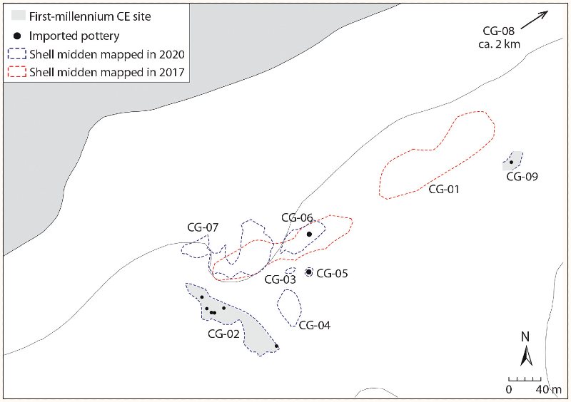
The most significant sites near Berbera are located in the surroundings of Ceel Gerdi, a small hamlet west of Siyaara and 22 km east of Berbera (see fig. 14). Here, six shell middens extend for 6 km along the coast, of which three are Neolithic and can be dated to the second millennium BCE through ceramic parallels in neighboring Djibouti.68 The other three—Ceel Gerdi 2 (CG-02), Ceel Gerdi 8 (CG-08), and Ceel Gerdi 9 (CG-09)—could be dated through imported artifacts to the first millennium CE (fig. 17). South of Ceel Gerdi 4 (CG-04), in the village of Ceel Gerdi itself, an off-site scatter was found, consisting of half a dozen sherds of plain, handmade pottery and a possible imported sherd, which may also be from the first millennium CE. Both CG-02 and CG-09 were located in flat areas with coral outcrops next to large dunes, whereas CG-08 was on top of a consolidated dune. CG-02 extends along a northwest–southeast axis and is much longer than it is wide, with a maximum length of around 135 m, a maximum width of 20 m, and a total surface area of 2,800 m2 (online fig. 6). Shells are evenly distributed throughout the scatter, but pottery and imported artifacts are more abundant in the northwest zone. CG-08 is located 2.7 km northeast of CG-02. It is composed of two small scatters covering a surface area of 1,500 m2 (online fig. 7). The actual size of the shell midden might be slightly bigger, as only exposed areas of the site were mapped. The density of shells is similar at CG-02 and CG-08, but pottery and other finds are fewer and less diverse at CG-08. CG-09 is a small shell scatter of around 100 m2, situated southeast of a large Neolithic midden (CG-01).
None of the sites are stratified; shovel tests revealed that all remains are on the surface, indicating low occupation redundancy and low spatial congruence.69 This means that people were returning to the same place, but not to the same spot, which makes sense, as the many shells, often large, would have hampered repeated occupations. This explains the abundance of shell middens along the coast and, within the middens, specific scatters that may represent different visits to the area. All middens were likely the campsites of small nomadic communities composed of a few nuclear families. In his classification of occupation density of pastoralist sites in northeast Sudan, Sadr considered sites with 25 sherds or fewer per square meter to be low density, while those with 100 or more were high density.70 At CG-02 there are 8.5 sherds per square meter in the area with more finds. If, as Sadr proposes, artifact density correlates positively with duration of occupation, then the occupations of the Ceel Gerdi middens were short. The sites yielded a variety of materials including handmade pottery, imported pottery, flint flakes and cores, ostrich egg shells, turtle shells, fish bones, and, of course, sea shells. Finds that appear only in CG-02 include animal bones, handstones, pounders, and net sinkers.
Marine shells, as might be expected, are the most common find. They range from 34 to 50 specimens per square meter, on the surface (Table 5). In CG-02, two units, of 2 × 2 m and 1.5 × 2 m, were sampled to assess the malacological assemblage (online fig. 8). In CG-08, the shells are dominated by Lambis and Tricornis, but there are scatters, probably representing different episodes of consumption, where different species prevail. In a cockle scatter, a 1.5 × 1.0 m sample unit (see Table 5, CG-08, Sample 1) yielded 74 shells and many shell fragments, one pottery sherd, and one fragment of ostrich egg shell. The density of the scatter, both in terms of shells and pottery, is lower than in CG-02.
Table 5. Shells from samples in middens CG-02 and CG-08 at Ceel Gerdi.
| Taxon | CG-02, Sample 1 | CG-02, Sample 2 | CG-08, Sample 1 |
|---|---|---|---|
| Tricornis tricornis | 114 | 17 | 17 |
| Callista umbonella | 7 | – | 4 |
| Sea snails | 7 | – | 10 |
| Tectus dentatus | 3 | – | – |
| Anadara antiquata | 2 | – | 41 |
| Chicoreus erythraensis | 2 | 1 | – |
| Conus namocanus | 1 | – | 2 |
| Littorinidae | 1 | – | – |
| Lambis truncata | – | 25 | – |
| Total | 137 | 43 | 74 |
The people of Ceel Gerdi were exploiting other marine resources, such as fish and sea turtles. Fish bones appear at both sites, one in CG-02 and five in CG-08. Fish vertebrae belong to the Serranidae family (two in CG-08, one in CG-02), probably a kind of grouper. Two other vertebrae in CG-08 are of the Sparidae (e.g., sea bream) or Lethrinidae (emperor fish) family. All are littoral, sedentary fishes that can be fished all year round near the coast (even from the coast) and live along shores with rocky bottoms, as is the case in Ceel Gerdi. The Periplus Maris Erythraei (7, 8), however, mentions the people of this region, the Barbaroi, sailing in rafts to trade with Muza and Okelis, markets on the Yemeni coast, for Barbarian incense and wood, so they may have sailed for fishing. Apart from the fish bones themselves, evidence of fishing is provided by stone net sinkers.
That the communities of Ceel Gerdi were not only foraging is demonstrated by the bones of goats or sheep, found in CG-02. Surprisingly, remains of larger Bovidae (size 3) are as common as those of goat/sheep (Table 6).71 It is impossible, unfortunately, to tell whether they are domesticated or wild, but the presence of cattle in Ceel Gerdi would be surprising, as the aridity and lack of water could not sustain them, even seasonally. Size 3 wild animals in the region include antelopes such as Oryx beisa and Tragelaphus strepsiceros. The former was abundant on the coastal plain around Berbera until the early 20th century;72 the latter exists in the nearby mountains. Another option is that the bones do belong to cattle obtained through trade in the highlands and slaughtered and consumed on the coast. Whatever the case, it diverges from the expected faunal assemblage of a nomadic group in Somaliland, which would include a large number of goats or sheep and a few camels, as documented for the medieval and postmedieval periods, but not large Bovidae. A camel metatarsal was also documented in CG-02, the oldest occurrence of this species so far in Somaliland. A fragment of a rib from a size 4 herbivore could also have belonged to a camel. CG-02 also delivered several handstones, which could have been used for a variety of purposes, among them perhaps grinding cereals. In sum, the nomads of Ceel Gerdi were engaged in a mixed subsistence economy: they were grazing their herds, fishing, collecting mollusks, and probably hunting. Foraging activities still contributed greatly to the pastoralists’ diet in Africa during the first millennium CE; in faunal assemblages from pastoralist sites in Roman Libya, for instance, gazelle represents up to 20% of the collections.73
Table 6. Faunal remains found in CG-02 at Ceel Gerdi.
| Taxon | No. | Skeletal Part | Section | Taphonomy/Other |
|---|---|---|---|---|
| Bovidae, size 3* | 3 | humerus | diaphysis | high weathering |
| Bovidae, size 3 | 1 | vertebra | axial | 2 cut marks (transversal incisions) |
| Bovidae, size 3 | 1 | vertebra | axial | – |
| Bovidae, size 3 | 1 | femur | diaphysis | weathering |
| Bovidae, size 3b | 1 | mandible | cranial | moderate weathering, biochemical alterations |
| Bovidae, size 2 (goat/sheep?) | 3 | rib | axial | – |
| Bovidae, size 2 (goat/sheep?) | 2 | mandible | cranial | premolar 3 not erupted |
| Bovidae, size 2 (goat/sheep?) | 1 | radius | diaphysis | high weathering |
| Goat/sheep | 1 | molar 3, lower right | cranial | – |
| Goat/sheep | 1 | molar 2, lower right | cranial | – |
| Camelid | 1 | metatarsal | distal epiphysis | – |
| Chelonia | 8 | shell | shell | high weathering |
| Bovid, indeterminate | 5 | tooth | cranial | – |
| Undetermined, size 4 | 1 | rib | axial | high weathering |
| Undetermined | 13 | – | – | poorly preserved corticals |
| Total | 43 |
Regarding pottery, seven different fabrics were identified at both sites (six of them are described in Table 7), of which one is surely local and another one perhaps as well; local fabrics represent 95% of the assemblage (online fig. 9). The most common fabric is brown to gray in color, with poorly sorted, abundant granitic temper, and untreated surfaces. Shapes associated with this fabric are handmade unrestricted and globular bowls, often decorated with incisions or shell impressions—quite distinct from the comb impressions characteristic of the Neolithic. Shell impressions were made using valves of Anadara, a mollusk that appears in noticeably large quantities in middens only during this period, as we have seen above. Handmade pottery of the first millennium CE is clearly an evolution of local Neolithic traditions: while decorations differ, the shapes and fabric are identical. Several of the sherds have holes that were drilled after firing. This allowed the pots to be hung using a rope, a solution that is particularly suited to the nomadic lifestyle. The very limited range of pottery forms is also typical of nomadic and seminomadic groups.
Table 7. Imported pottery found at Ceel Gerdi (CG) and Siyaara, by fabric type.
| Type | Description | Provenance | CG-02 | CG-05 | CG-07 | CG-08 | CG-09 | Siyaara | Subtotal |
|---|---|---|---|---|---|---|---|---|---|
| Fabric 2 | red, compact, scarce, fine temper | Aksumite, west-central Tigray? | 5 | 1 | – | 2 | 1 | – | 9 |
| Fabric 3 | brown-red outside, gray inside, coarse granitic temper | Himyar/Yemen | 1 | – | – | – | – | 3 | 4 |
| Fabric 4 | gray, friable, shell-tempered | Oman / Persian Gulf | 1 | – | – | – | – | – | 1 |
| Fabric 5 | gray, abundant temper, volcanic | Late Aksumite, eastern Ethiopia | 1 | – | – | – | – | – | 1 |
| Fabric 6 | wheelmade, pink, fine muscovite | Mediterranean? | 2 | – | – | – | – | – | 2 |
| Fabric 8 | ocher, compact, well levigated | unknown | – | – | 1 | – | – | – | 1 |
| Total | 10 | 1 | 1 | 2 | 1 | 3 | 18 |
Regional and Long-Distance Trade in the Berbera Region
A variety of imported pottery was found in the shell middens at Ceel Gerdi. A minimum of seven vessels were found in CG-02, including a wheelmade one in pink fabric and fine muscovite temper, perhaps from the Mediterranean; several sherds of brick-red pottery; and two fairly complete pots, a Himyarite jar similar to those of Siyaara and a Late Aksumite jug (fig. 18; Table 7). The latter shows two characteristic elements of Late Aksumite production (550/610–800/850 CE):74 black surface and geometric decoration. The paste (Fabric 5) has an abundant mineral temper, including volcanic inclusions. Similarities in terms of fabric and decoration are greater with the Agame pottery tradition of eastern Tigray than with productions from Aksum itself or southern Tigray. Interestingly, the pottery technique resembles contemporary traditions in Adigrat, also in eastern Tigray.75
Regarding the brick-red fabric (Fabric 2), the sherds are compact, hard, and homogeneous in color, but coarsely molded and with some muscovite temper. The walls are thick, suitable for cooking or storage pots. The surface has a characteristic polishing and striating caused by brushing. This fabric resembles Classic and Middle Aksumite period utility or tableware (globular pots, goblets, cups, and bowls with polished to slipped surfaces).76 Given the absence of good diagnostic elements, it is difficult to confirm a provenance, but red fabrics were common in central-western Tigray and similar fabrics are still found in modern productions in the area. In association with these reddish sherds, there is a small fragment in CG-08 of a rim from a globular pot, which can be described as Black-Topped Ware. This type of pot, with a reddish external surface and a blackish band around the rim that continues on the internal surface, is dated to the first millennium BCE. Nevertheless, echoes of this typical pre-Aksumite production are present in a few cases (or present in low numbers) in the later ceramic assemblages of the Proto- and Early Aksumite periods (ca. fourth century BCE to second century CE) in several sites in Tigray.77
Another of the fabrics documented at CG-02, a gray ware with abundant coarsely crushed shell inclusions (Fabric 4), has been found in Oman and the United Arab Emirates.78 Two vessels in this fabric appeared at Ras Hafun, where they had clearly been imported.79
Imported materials appeared in other scatters dominated by Neolithic materials besides CG-02 and CG-08. This makes sense, as two of the Neolithic middens are contiguous to CG-02 and the people from the later site surely moved around the surrounding dunes. Such finds include two handles, which are unknown in the local tradition and therefore must have been imported. One of them is a flat vertical handle in red fabric with little temper, for which good parallels have not been found. The other one is a horizontal lug handle, oval in section, with impressed decoration and ochre fabric with a little temper (Fabric 8). While horizontal handles exist in the Aksumite area, no convincing comparanda exist for this piece. There is also the possibility that it is a medieval intrusion, as horizontal handles are common in medieval sites in Somaliland. However, it would be the only medieval sherd in the entire assemblage.
Also imported are two pieces of obsidian at CG-08, a bladelet core and a flake. Obsidian from Yemen and northern Ethiopia was part of long-distance and regional trading networks involving the Horn of Africa and South Arabia from the Late Neolithic onward and these finds must therefore be considered trade items on an equal footing with pottery and glass.80
Finally, the most remarkable of the foreign artifacts from the shell middens is a bracelet of plano-convex section in a monochrome very dark green (almost black) glass found in CG-02. This kind of bangle is common in Egypt and the Levant between 300 and 700 CE and particularly abundant between the fifth and seventh centuries CE, a date coincident with the Aksumite jug.81 Compared to those at Xiis, imports from Ceel Gerdi reflect a regional trading network involving the Horn and South Arabia rather than the long-distance network revealed at Xiis. However, we must bear in mind the nature of Ceel Gerdi—campsites of small nomadic communities foraging along the coast, rather than a proper place of trade as Xiis was.
With what were the nomads trading? According to the Periplus Maris Erythraei, the items traded in Malaô and Mundu were the same, which means different types of incense and myrrh and a few slaves. The people of Ceel Gerdi might have brought incense that they had harvested during their trips from the interior to the coast, but they could also have provided marine resources; namely, turtles. Both CG-02 and CG-08 have furnished several turtle shell fragments. Casson noted that turtle shell receives more mentions than any other item in the Periplus,82 and in the account of the Somali coast, it is mentioned in descriptions of Avalites (Periplus 7), Mosyllon (10), and Opône (13), as well as of the island of Socotra (Dioscurides) off the coast of Somalia (30), so it is quite likely that they were also hunted and sold elsewhere. Green turtles were abundant in the Gulf of Aden and have been found in shell middens from the Bronze Age onward.83 Many turtle bones were retrieved in the excavations of Ras Hafun Main, and the absence of shells has been convincingly interpreted as the latter being sold to merchants.84 Another item that could have been traded is ostrich eggshells, several fragments of which appeared in both CG-02 and CG-04. Trade-in ostrich eggshells is documented for the early Islamic period in the region.85 Exchanges were not necessarily conducted in Ceel Gerdi itself, but they could have taken place in the whereabouts of either Siyaara or Berbera.
The sites of Ceel Gerdi can be dated to between the fifth and seventh centuries CE based on the chronology of the Aksumite jug and the glass bangle. This period partly coincides with the hegemony of the Aksumite presence in the Red Sea and the Gulf of Aden during the sixth century.86 Indeed, in Adulis, the main trade center on the Eritrean coast, the most intense occupation is in the fifth and sixth centuries CE, which is also when more abundant pottery imported from the Ethiopian highlands appears. This is interpreted as proof of the stronger inclusion of the coast in the sphere of influence of the Aksumite kingdom during the sixth century.87 At the same time, evidence of South Arabian materials in both Ceel Gerdi and Siyaara speaks of relations between locals and the polities of the Yemeni coast, a phenomenon that is already attested in sources for the first century CE (Plin., HN 12.42.88; Periplus 7–8).
The Inland Routes
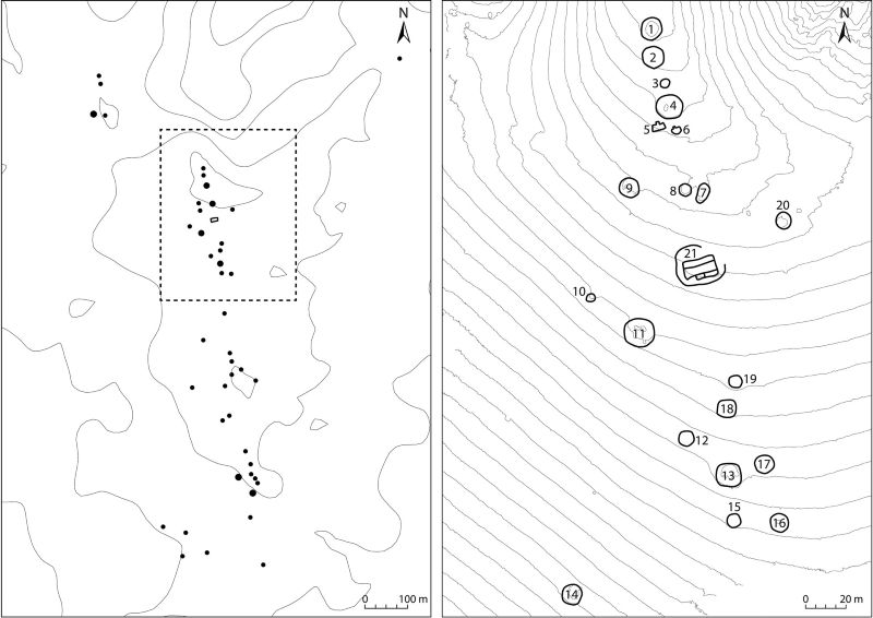
The hinterland of Berbera as far as Yiroowe (south of the town of Burao) was also explored through extensive surveys combined with analysis of satellite imagery, covering a tract of some 130 km in a straight line from the coast. In the area between the escarpment dividing the coastal plain and the highlands and the Burao area, we located 22 necropoleis with cairns flanking the main natural routes. One of the largest cemeteries is in Gugux, east of the town of Sheikh and 65 km south of the coast. The complex consists of 44 tumuli and one large rectangular and segmented structure (fig. 19). The tumuli range in size from 5 to 15 m in diameter and are between 1 and 2 m in height. The cairns are disposed following a perfect north-south orientation along an elongated hill with the same orientation. Unfortunately for the dating of the site, there were no associated surface finds. However, the cairns were intact, indicating the site has not been looted or disturbed by natural processes, so future archaeological work can be productive.
Another necropolis, Galoley, extends along a wadi near the main road linking the coast and the town of Burao. Here a partially looted cairn was excavated and yielded no finds whatsoever. Another cairn, some 3.5 m in diameter (online fig. 10), which was not aligned with the main group of tombs, had some bones protruding from the stones. One of them was taken for radiocarbon analysis and yielded a postmedieval date.88 The bones might be a later intrusion since they appear in the upper part of the cairn, or the cairn itself might be recent.
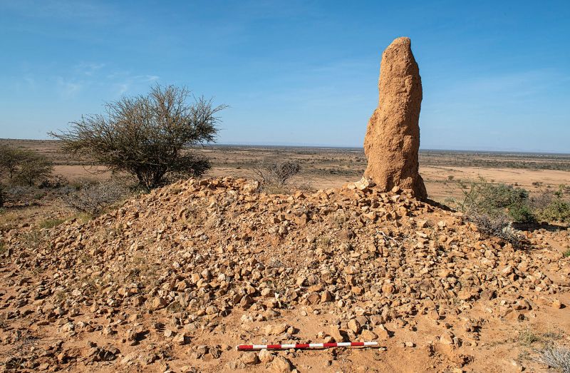
Another site was more productive: on a flat-topped hillock in Yiroowe, 22 km southeast of Burao, rising some 30 m from the surrounding plain, sits a smaller necropolis, with only four cairns. Two of the cairns are on the eastern edge of the hilltop and two are on the southern slope. Those on the hilltop were larger, with a diameter of around 12 m, and made of small stones (ca. 0.1 m). Those on the slope were smaller (ca. 4 m in diameter) and probably later in date—smaller cairns were in use in the region at least until the 19th century (as seen in the case of Galoley), whereas no large cairns are known to have been built after the early second millennium CE. One of them was half destroyed and furnished no finds whatsoever. The larger cairns, however, did yield some materials, because they had been disturbed by anthills (fig. 20). The southern tumulus had several fragments of turquoise glass on the surface, mixed with the stones of the cairn, which was disturbed. The fragments come from a single vessel whose shape could not be reconstructed. The glass is patinated and clearly ancient, although it is difficult to specify a date. Next to the northern cairn a glazed pottery sherd turned up. The type of glaze—green and crazed—and the buff, friable fabric, are quite unlike those of the medieval period in color and texture but are strongly reminiscent of the Mesopotamian Glazed Ware found in Xiis (fig. 21). A date before 700 CE is most likely, as Muslim graves do not typically have funerary offerings.
Cairn cemeteries were established along the main natural routes between coast and interior followed by nomads (still today), and it can be expected that these graves would have commodities exchanged with foreign merchants. Large concentrations of smaller cairns, such as those documented at Xiis, however, are unknown in Berbera and its hinterland. Before excavation, we cannot say whether the larger tombs were collective or individual, as in Xiis, but based on size and parallels elsewhere in the Horn, collective use seems more likely.
Other Far-Side Ports?
We visited Zeila, which has been traditionally identified with the ancient port city of Avalites.89 There was nothing on the surface predating the 13th century, and previous researchers have failed to discover pre-Islamic remains, either in excavation or on the neighboring Sacadin Island, where medieval sherds and structures are abundant.90 That the Zeila region played an important role in pre-Islamic times, however, can be inferred indirectly by the abundance of large cairns flanking the natural routes leading from the Borama highlands to the coast. It is possible that ancient remains are buried deep or somewhere else in the area. A more systematic survey of the region is needed.
According to the Periplus Maris Erythraei, the ancient settlement of Mosyllon was located between Mundu and Arômatôn Emporion. As noted above, it is possible that Mundu corresponds with Xiis. As for the Arômatôn Emporion, it has been identified with Daamo, where Chittick found Mesopotamian Glazed Ware and Dressel 2–4 amphoras.91 Mosyllon could be located either in Qandala in Puntland or Ceelayo, on the border between Somaliland and Puntland.92 Satellite photographs show large necropoleis in both locations, very similar to Xiis in size, cairn typology, and organization. The necropolis at Qandala is located east of the town near an estuary that penetrates deep inland (online fig. 11). The cemetery has doughnut-shaped cairns identical to those at Xiis and the tombs are similarly arranged. Around 200 cairns can be detected in the satellite imagery, adjacent to an escarpment facing the sea, as in Xiis. The majority of the burials are apparently circular or doughnut-shaped, ranging in size from 2.5 to 17 m. Those with greater dimensions are larger than any known in Xiis, but the most common cairns in Qandala are less than 10 m in diameter, as in Xiis. The site could not be visited, as the situation in Puntland is not as safe as in Somaliland, but the necropolis is so similar to Xiis that a contemporary chronology can be posited. As for Ceelayo, near the border of Somaliland, the cemetery is even larger, with perhaps as many as 500 tombs, extending 6 km parallel to the coast, between the dunes and an escarpment (a topographic setting again reminiscent of Xiis). The tombs include large circular and doughnut-shaped cairns, and in this case, also dozens of square structures like those of Ras Hafun and Xiis. Again, given the similarities to those dated sites, the time frame is most likely the first half of the first millennium CE.
Discussion
Research on the sites of Xiis and Ceel Gerdi confirms much of what was already known from written sources and from the few archaeological materials from previous explorations.
However, it also provides new insights that challenge some preconceptions. The places differ in nature and chronology. Based on the available data, Xiis seems to have been in use mostly (or perhaps only) between the first and third centuries CE, after which trade may have moved elsewhere, not necessarily very far, as there are other cairn clusters in the area. This proposed chronology could change should the square tombs prove to be later in date. The middens of Ceel Gerdi, however, were in use at some point between the fifth and seventh centuries CE. They reflect nomadic camps, where people engaged in a diversity of subsistence activities, typical of a mixed economy—and also trading, both regional and, to a lesser extent, long distance.
In Xiis, research has confirmed that the nomads had high purchasing power, which was already known from Révoil’s collection. This should come as no surprise: pastoralists have already been shown to have access to luxury goods, including gold jewelry, in other areas, such as Late Roman Egypt,93 thanks to their control of key resources and routes. Yet due to the influence of classical texts and limited archaeological knowledge, the commodities acquired by nomads are still often referred to as “commonplace,” “inexpensive,” or “low value.”94 The distribution of imports throughout the necropolis of Xiis indicates that Révoil’s finds were not a unicum and that high-quality goods from the Roman and Parthian empires were arriving in Somaliland in good numbers during the first centuries CE (fig. 22). Among the clearest evidence of such purchasing power are the glass plaques and tiles embedded in boxes, with close parallels in the royal tombs of Meroe. This wealth must be related to the virtual monopoly that the people of Somaliland had on one of the most expensive products of the ancient world: prime quality frankincense, one pound of which equated to 50 days’ pay of a skilled laborer in Rome.95
Other conclusions are more counterintuitive. First, the Xiis assemblage as a whole—which includes Mesopotamian Glazed Ware, terra sigillata, fine glass, wine, and perfumes—is not so different from that of other regions involved in the Indo-Roman trading network during the first to third centuries CE. The nomads were partaking in a shared world that was not only economic but also cultural. They were acquainted with foreign practices and scales of value and were strongly integrated into the Western Indian Ocean system. The volume and diversity of imported items along the northern Somali seaboard indicates sustained interaction rather than sporadic visits by foreign merchants.
Second, imports were not only for individual use as grave goods. The presence of large numbers of containers (South Arabian jars and Roman amphoras) points to practices of collective consumption that had passed unnoticed so far. We now have the two sides of the coin: individual consumption of status symbols, as reflected in luxury items in graves, and collective consumption of perishable products, probably wine and food, most likely in the context of rituals, banquets, and funerary ceremonies. The abundance of containers could be associated with acts of communal consumption in which status was displayed and negotiated, as in other societies living on the peripheries of the Roman empire, pastoralist or not.96 The import of wine by East African communities is mentioned in the Periplus Maris Erythraei (17) in connection with Rhapta. Here it is stated that wine was imported not as a trade item but as a way of facilitating commerce with the Barbaroi, which can be interpreted as wine being used in feasting between locals and merchants or among locals. Also, annual communal feasting by indigenous communities is described in the Periplus (65), though in reference not to Africa but to India. In Xiis itself, the contexts of amphora deposition could perhaps be related to feasting by nomads and merchants to facilitate commercial exchanges; these kinds of ritualized celebrations are known in other archaeological and historical contexts of trade—including in Somaliland itself, where they have been attested for the medieval period.97 For the moment, this is just a theory. Another possible explanation for the Xiis amphoras is that nomads transferred the contents of the amphoras to animal skins in order to transport the wine to the interior and discarded the containers in situ.
Another aspect revealed by archaeology is the individual nature of many of the tombs in Xiis, Ras Hafun, Ceelayo, and Qandala. This is remarkable; the little we know of Neolithic burials in the region indicates that they were collective.98 The same is true for late first-millennium CE cairns in Ethiopia.99 Unfortunately, diachronic knowledge of burial customs in Somali-land is extremely patchy, but individual tombs seem to prevail during the first few centuries CE and again beginning in the 13th century.100 This coincides with peaks in long-distance trade and increased social differentiation. More graves need to be excavated at Xiis to confirm this, but the appearance of individualism and rich grave goods is already telling and might be related to the emergence of inequalities without centralization or sedentism. In this regard, the existence of elaborate children’s tombs with, in one case at least, luxury goods, may indicate ascribed status or the projection of the parents’ status onto their offspring.
As for Ceel Gerdi, it is impossible not to think of the Ichtyophagoi, the Fish-Eaters, situated by Greek writers from the sixth century BCE onward along the Red Sea coast and the Gulf of Aden. They are a topos of savagery in Hellenistic to Byzantine literature, in which they are variously described as naked, living on shellfish and fish cast upon the shore, eating them raw, dwelling in small, poor villages, and using wooden and lithic implements.101 The cliché, as is almost always the case, includes both an element of truth and a distortion of reality. The Ichthyophagoi of Ceel Gerdi may have looked primitive from the perspective of Mediterranean cultures, but they were also engaged in commercial networks involving the Byzantine empire, Oman, and the kingdoms of Himyar and Aksum, and were well acquainted with their material culture. This participation in long-distance and regional trade is actually hinted at by Artemidorus (ca. 100 BCE) and the author of the Periplus Maris Erythraei, who mention the Ichthyophagoi of the Horn of Africa providing myrrh and turtle shell to merchants.102 Now we know that they maintained their involvement in trading networks until late antiquity—and later.
It is obvious that the author of the Periplus considered the people of each of the far-side ports a distinct group—akin to what we would call an ethnic group—but the text revealed very little of their cultural specificity. This is one of the aspects to which archaeology can make an important contribution. There is the tendency to see pastoralists as a single cultural complex from Egypt to Somalia. The sources provide little detail about their lives, except some clichés regarding their diet and a few comments on their propensity to trade, or lack thereof. While there is still much that a careful examination of classical texts can do, it is obvious that only archaeology can provide a full picture of the cultural distinctiveness and sociopolitical organization of each of the pastoral groups that lived along the shores of the Red Sea and the Gulf of Aden. As noted at the beginning of this article, all nomads rejected sedentism and centralization and shared similar ways of constructing and using the landscape. But their cultural variability and dynamics over time, then as today, were immense, and this clearly shaped the ways in which they interacted with foreign merchants.
Another lesson from recent research in Somaliland is that we should not always try to fix the trade on the African coast to specific locales as mentioned in the ancient sources. The proclivity to do so is influenced by the urban-centered imagination of the Mediterranean societies (and our own), but in nomadic areas, the situation was probably quite different. For medieval and postmedieval times we know that places of trade were volatile and could change in a matter of months—due to clan conflicts, for instance.103 This volatility was underscored by the lack of both infrastructure that anchored people to specific locales and centralized authorities. For the first millennium CE, more sites have been documented along the coast than are known in ancient sources, and this might be related to the shifting landscape of trade in Somaliland and Puntland. This, in turn, has to do with nomadic heterostasis, which comprises flexible politics and a strategic use of mobility.104 Places of trade were mobile because the local communities were mobile themselves. The movement of pastoralists followed an annual rhythm marked by the monsoon winds. The monsoon brought rains—and thus grass for the herds—during specific times of the year. It also brought foreign sailors, whose movements, in this case by sea, were equally determined by the regime of the monsoon winds, which seems to have been fully mastered by the end of the first century BCE.105 The trading season and the grazing season along the coastal strip coincided and made the interaction between nomads and merchants possible for two millennia. Therefore, the sites that we have documented were most likely the locations of seasonal fairs that lasted for a few months and whose nature does not seem significantly different from those described in the mid 19th century by European travelers.106
Conclusions
The participation of Somaliland in the Western Indian Ocean network has been known from archaeological remains since the late 19th century. However, no systematic work has ever been conducted in this territory. Recent research in the necropolis of Xiis, which was discovered in 1881, and in the sites around Berbera, has provided a wealth of data that enable a better understanding of long-distance and regional trade in the Gulf of Aden during the first millennium CE. Perhaps more importantly, it provides new insights into nomadic societies in the Western Indian Ocean system. Of all the actors involved in the network, nomads are the group that has received by far the least attention from archaeologists and historians. This is despite the fact that nomadic pastoralism was the dominant subsistence strategy from Egypt’s Western Desert to southern Somali (more than 6,000 km of coastline) and these groups had control of highly valued resources such as turtle shell and frankincense. Research in Xiis, commonly associated with ancient Mundu, has resulted in the first detailed map of the necropolis and a reliable chronology. It has also confirmed the wealth of the nomads participating in trade and their strong integration, both cultural and economic, in the Western Indian Ocean system at the beginning of the Common Era. While the presence of high-quality glass was already known, an important number of Roman amphoras and South Arabian storage jars have been collected, as well as terra sigillata and Egyptian fine wares. Two ostraka with Greek graffiti confirm the presence of merchants from the Roman empire on Somali shores. Indo-Roman trade in Somaliland may have influenced the practice of individual burial—the few earlier graves excavated to date are collective—and an increase in social differentiation without this leading to either centralization or sedentism.
Fieldwork in the Berbera region, identified with ancient Malaô, has documented a rather different panorama. No extensive necropolis has been found, but several shell middens bearing evidence of contact with the kingdoms of Himyar and Aksum in late antiquity were identified. The people in the surroundings of Berbera were not the typical specialized pastoralist society with which we have come to associate nomads, but rather mobile communities with a mixed economy in which the exploitation of marine resources and probably other foraging and hunting activities played a prominent role. This reveals the heterogeneity of the nomadic populations of the Horn of Africa, which is quite different from the stereotypical image inherited from antiquity and that still prevails in the contemporary imagination. The documentation of many pre-Islamic cemeteries following the routes to the coast in the Berbera hinterland reveals a complex network that linked the shores of Somaliland and the interior of the Horn of Africa.
In both Berbera and Xiis, research has shown, on the one hand, that regional networks—involving the Horn of Africa and South Arabia—played a more prominent role than could be inferred from written sources alone and, on the other, that Parthians were primary actors during the first few centuries CE. Further research will surely provide a more accurate picture of those nomads who traded with empires.
Appendix. Descriptions of the Tombs Excavated at Xiis
Candela Martínez Barrio
Tomb 49 (Cluster 2)107
This tomb had no cairn, the structure consisting of a simple stone ring of 2.60 m in external diameter delimited by medium-sized stones (0.3–0.5 m) placed directly on the ground (see fig. 7). This is one of the seven circular structures without cairns documented in this area, and it was selected to determine whether they were tombs or had a different purpose. There were no obvious traces of looting on the surface, such as pits or displaced rubble, but the excavation showed that the grave had in fact been plundered. Surface cleaning yielded three small fragments of light green glass, two of them rims, apparently from a beaker, but it cannot be determined with absolute certainty that they come from the tomb rather than from any of the nearby structures. After the removal of the surface layer inside the stone ring, two well-defined stratigraphic units appeared: a layer of reddish sand interspersed with numerous small white stones covering most of the area and a small oval shape of gray sand west of it. Initially, the latter was interpreted as the fill of the tomb’s pit, but it was later realized that it was actually a robbers’ pit. The actual, much larger, burial shaft was elongated and lay underneath the robber’s pit, with a southwest-northeast orientation. The remains of a human skeleton were documented 1 m deep in a supine position at the bottom of the pit. No objects were found in association with the bones, except for a small sea snail with a perforation to use as a pendant. It appeared in the fill, near the feet, so it is not possible to tell with certainty whether it belonged to the individual or not. Several attempts at dating various bones were unsuccessful as they had no collagen left, which leaves us without a chronology for this context. Should the glass belong to the tomb, the dating would be between the first and third centuries CE.
The human remains, which were in a good state of preservation compared to other burials, appeared in two different stratigraphic units. Some of the bones appeared mixed and disarticulated in the robbers’ pit filled with gray sand. Among the disturbed bones there were fragments of a mandible; some teeth; ribs; the right humerus, radius, ulna, and hand bones; vertebrae; and the right coxal. The rest were indeterminate bone fragments. The looters dumped the bones in the pit after plundering the tomb. Lying on the bottom of the grave, in situ, was the lower third of the skeleton. It was lying on its back with the right hand stretched along the body and the left hand over the abdomen. The lower limbs were extended. The individual’s age was estimated based on the measures of the long bones. The maximum length of the diaphysis of the femur and tibia (without epiphysis) provide an age between 5.5 and 6.5 years at the time of death.108 Dental development could not be used to calculate age, as only a fragment of mandible and some loose teeth were found. Biological sex could not be determined either. Some characteristics of the long bones and ribs are compatible with a potential pathology, but this requires further examination.109
It is possible that the deceased had grave goods and that they were located in the area of the head, which had been heavily disturbed and partially removed. The thorough destruction of the upper third of the skeleton would suggest that there were indeed some objects, and the presence of glass shards would suggest that at least a beaker was part of the grave goods. Alas, the disturbance of the context prevents definite conclusions.
Tomb 75 (Cluster 3)
This is a fairly intact cairn, albeit with some evidence of a looting attempt that affected its northern side. It has an oval shape of 2.7 × 2.0 m and a height of just 0.57 m. It is built with volcanic stones of medium size (0.3–0.5 m) with a ring of bigger stones (0.6–0.8 m) at its base. The cairn was selected because of its good state of preservation and small size (online fig. 12). The excavation started with the removal of the volcanic blocks, under which the second layer of blocks appeared—this time of coral and with a thickness of 0.4–0.5 m. Underneath the coral blocks appeared a third layer of volcanic stones placed flat on the ground, with an average thickness of 0.4 m. Under these three layers of stones, there was a deposit of white sand mixed with small fragments of coral stones and, underneath that, a homogeneous level of coral and light brown sand with no anthropogenic intrusions; this is in all likelihood geological. The pit, which had a northwest-southeast orientation, was 1.98 × 0.56 m and was filled with white sand mixed with shells and small coral fragments. At the base of this stratigraphic unit, there was a large flat stone on the southeastern side and the remains of a wooden framework embedded in red clay on the northwest. Once the flat stone and red clay were removed, human remains appeared, 1.4 m under the surface. The skeleton was complete but the state of the bones was not good; they had many postmortem fractures and crumbled easily upon exposure.
The individual had the head to the northwest, facing south, and the arms stretched along the body. The collapse of the wooden framework left visible traces on the bones in the form of dark brown horizontal stains. Two perforated shells, a cowrie and a sea snail, were found in the fill, so they do not belong unambiguously to the dead. No proper grave goods were documented and the sample bones that were taken for radiocarbon dating turned out, again, to have no collagen. No stable isotopic analyses could be conducted either, and a sample of wood dust also failed to deliver a date. After samples were taken, the skeleton was studied in situ and reburied. Tomb 75 revealed a careful and very elaborate funerary structure, which is quite uncommon. However, it is not matched by rich grave goods, as could have been expected.
The buried individual is male, which can be inferred from the cranium and coxal bones. The age was estimated based on the pubic symphysis and the auricular surface of the coxal bones: there are no traces of fusion in the bones and the third molar is completely erupted. The morphology of the symphyseal face places the individual in phase III, with a range between 21 and 46 years of age at the moment of death.110 The observation of the sacroiliac region suggests that the auricular surface of the individual is situated between phases II and IV, with a range between 25 and 39 years of age.111 Measurement of the long bones as well as the total length of the skeleton gave a height of approximately 1.68 m. The estimated stature using the maximum measure of the right humerus was 163.16 ± 4.43 cm and using the left femur was 167.41 ± 3.94 cm.112 The individual had remarkably good dental health, with no antemortem losses, cavities, or dental calculus. However, medium to advanced dental wear was observed, mainly in the molars, with several points of dentin exposed in the dental crowns.
There is no hypoplasia, fistula, or alveolar resorption. There are some nonmetric, individualizing features, including a marked concave impression on the inferior surface of the sternal (medial) end of the clavicle and some joint degeneration in the sternal face of the same clavicle.
Tomb 120 (Cluster 3)
Tomb 120 is a small circular cairn, 3.7 m in diameter and 1.5 m in height. It was made of medium-sized (0.2–0.3 m) volcanic stones forming a cone at the top and a ring of bigger blocks (0.7–1.0 m) at the base. The southern side showed evidence of an unfinished looting attempt.
Once the stone cover was removed, alternating layers of sand of different colors and compactness were found (light brown, slightly compacted; white, highly compacted) (online figs. 13, 14). It is possible that the white sand was mixed with gypsum (of which there are outcrops in the vicinity) to achieve more compactness in order to seal the grave. Two layers of compacted white sand interspersed with light brown sand were documented before the outline of the pit was found. It had an east-west orientation and was 1.60 m long, 0.50 m wide, and 0.67 m deep. In the fill, a single unmodified shell of Anadara uropigimelana was found. Lying on the bottom of the tomb was a skeleton, complete except for the feet, which had completely disappeared.
Tomb 120 yielded a small but very interesting assemblage of grave goods, consisting of a 22 cm tall Roman glass flagon lying next to the cranium on the right side; a necklace of 24 beads around the neck of the individual, 12 of which were blue glass, six were faience, and six were bronze, and an iron anklet on the right ankle. The glass flagon was cylindrical and had a combed handle; it can be dated to the third century CE (see fig. 11; online fig. 15).
The osteological analysis was conducted in the field. The individual was lying supine, head to the west, facing south, and arms stretched along the body. The state of preservation of the bones was not good. Preservation was particularly poor in the distal extremities of arms and legs. Numerous postmortem fractures and problems of bone consistency were probably caused by the pressure of the cairn stones. The skeleton is slightly tilted to the right due to post-depositional processes, but the joints are tight and there are no relevant bone displacements.
There is major decomposition and bone loss in the thoracic zone, pelvis, hand bones, knee joints, and ankles. No bones from the left hand, patellae, right fibula, or foot bones were found.
Based on dentition and the measurement of long bones, it can be ascertained that the individual was a child aged 7.5 to 9.5 years.113 To narrow down the age range, a radiograph would be necessary to assess not only tooth eruption but also the development of the crowns and roots of the permanent teeth yet to come out. The maximum measurements of the long bones provide an estimate of 4 to 5.5 years of age,114 but these measurements were taken in the field and are approximate because the extremes of the bones were not well preserved. It is thus possible these calculations underestimate the actual age; however, the estimate of 4–5.5 years can be utilized as the lower margin. No pathologies or traumas were documented. The biological sex of the individual cannot be determined. There is a strong association between the type of artifacts found in the tomb (particularly the necklace and anklet) and female individuals in the Horn of Africa, particularly those belonging to nomadic groups. Babies and toddlers are usually not distinguished by gender in terms of personal adornments, but distinction normally appears by three or four years of age.
Tomb 153 (Cluster 4)
When this tomb was recorded in 2018, a significant concentration of materials was found in its vicinity, including green-glazed Parthian pottery, amphora fragments, and glass, and it was thus targeted for excavation during the following field season. The tomb had been extensively looted and was in a very poor state of preservation, with the cairn almost completely dismantled.115 Its morphology is thus uncertain, but it seems that it originally consisted of a rectangular structure that was surrounded by a stone ring, lost for most of the perimeter. It seems that the structure was originally circular, approximately 6 m in diameter. The tomb was surrounded by other poorly preserved structures that had been eroded by torrents flowing from the slope of Ma’ajilayn Hill. The deposits documented during excavation were characterized by a high level of disturbance by looting. The southern part of the tomb was almost completely gone, while the northern part was better preserved. Deposits of light and dark sand were interspersed with medium-sized stones, seashells, and fragments of archaeological objects. Human remains were absent with the exception of five small fragments of 3 cm or less, of which only one could be identified; it was a phalanx.
Archaeological materials were, however, abundant, although strongly disturbed and mixed to the extent that pieces of the same object were found separated by a depth of 1 m. In some cases, the materials showed evidence of having been affected by fire, although given the level of disturbance of the grave it is impossible to determine in which context this process took place. The tomb was significantly deeper than the other three, reaching a depth of 1.8 m. The materials located in Tomb 153 are very diverse and representative of the site as a whole. They are also strikingly similar to those found by Révoil. At least 10 different objects have been identified. Glass fragments are the most abundant material, including monochrome and mosaic vessels and inlays. The monochrome examples correspond to at least three different vessels, but they are extremely fragmented, and only a pillar-molded bowl could be identified in the sample, dating from the first century BCE or first century CE.116 There were fragments of at least two millefiori bowls that can dated to the same period.117 Regarding inlays, a total of 25 strips in white or red glass paste were found, some with black palmettes. They originally decorated a box or casket. Pottery is represented by four items: a small vessel of Mesopotamian Glazed Ware with green glaze, straight neck, and flaring rim; a fragment of Italian terra sigillata; a sherd of a Roman amphora; and a bowl of Egyptian fine ware. The assemblage is completed by a carnelian bead, a glass bead, and a fragment of iron.
Supplementary Content. Online Figures
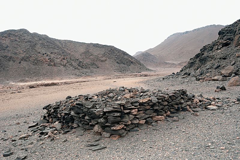
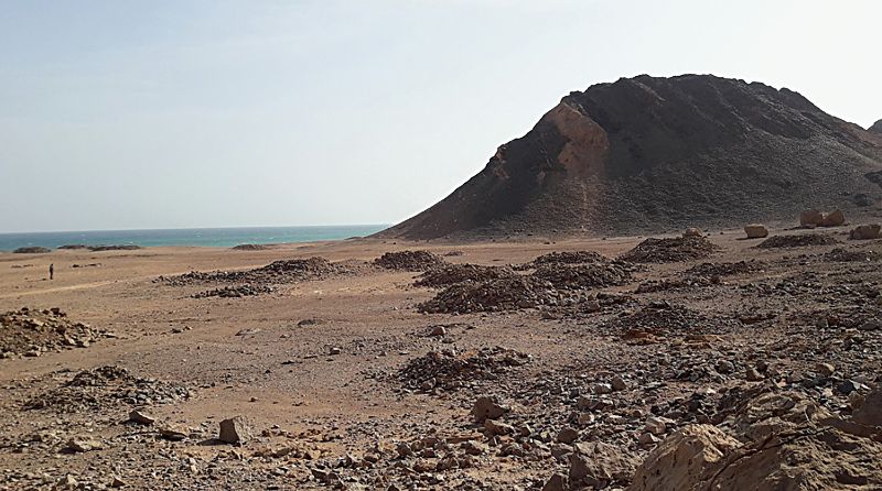

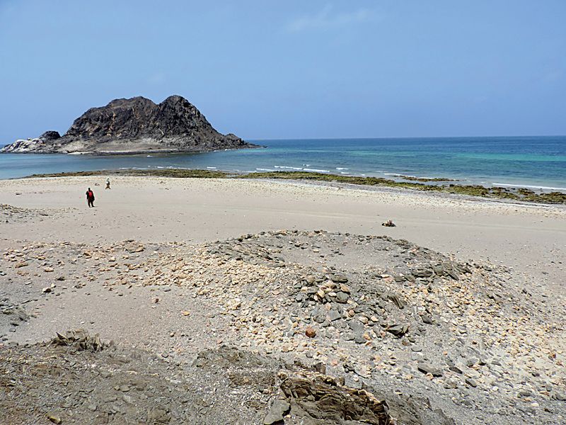
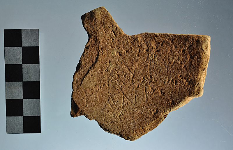
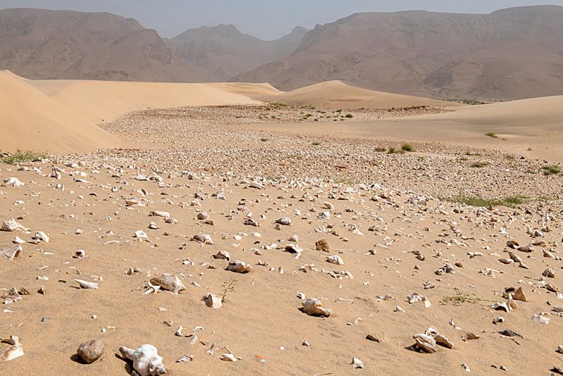
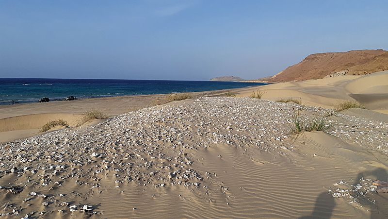
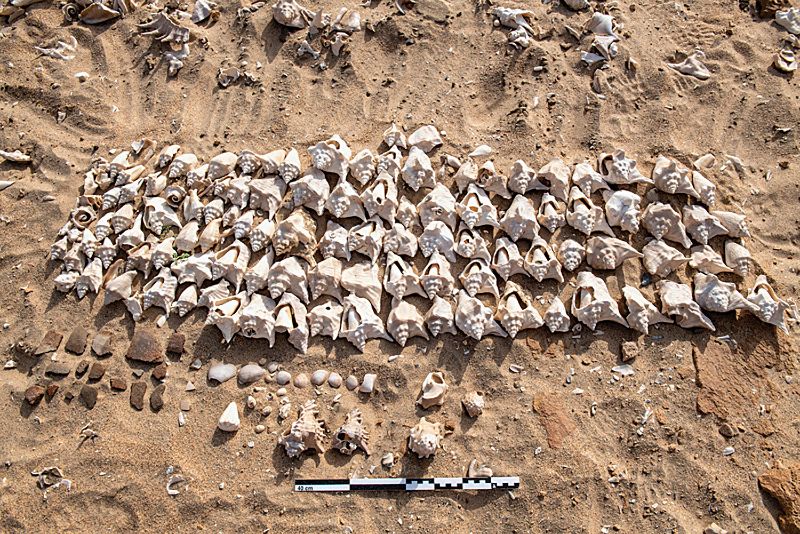
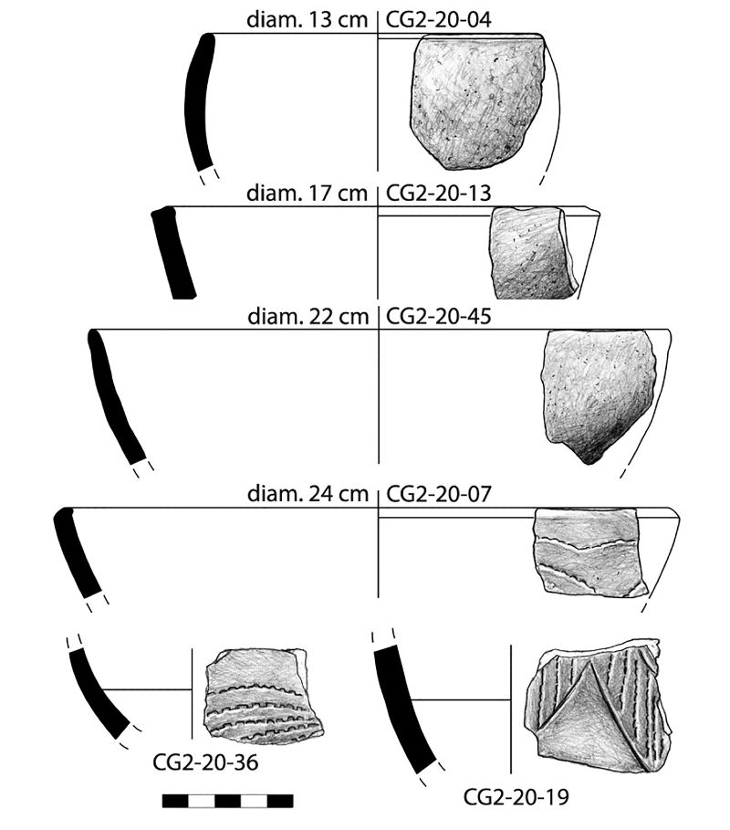
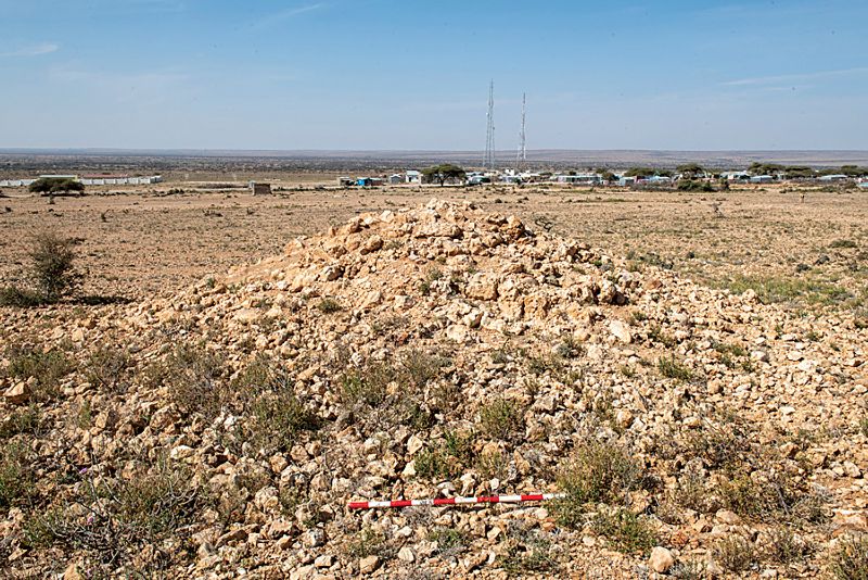

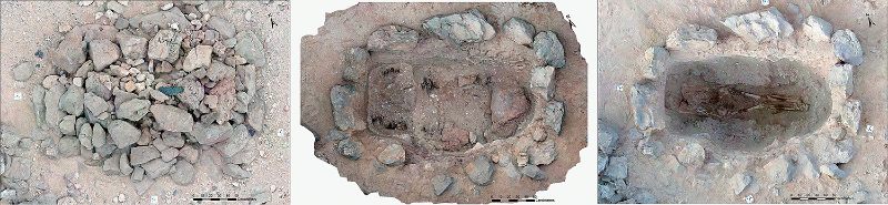
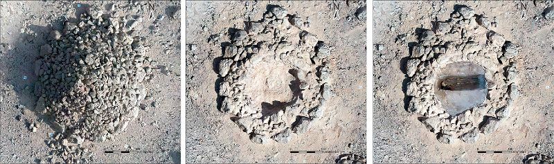
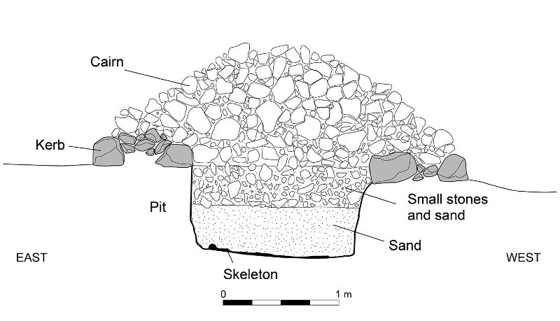
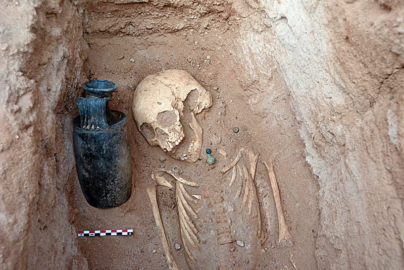
Notes
1 Funding for this research was provided by the Spanish Ministry of Science and Innovation (project PGC2018-099932-B-I00) and the Palarq Foundation. Arturo Morales (Autonomous University of Madrid) identified the fish remains from the shell middens of Ceel Gerdi. Special thanks to Abdilqadir Abdilahi Yusif for his friendship and invaluable support in the field, and Álvaro Minguito Palomares for the stunning photographs of the 2020 field season. Three anonymous reviewers for the AJA provided valuable comments that have helped improve the article. Any errors remain our own. Figures are the authors’ except as noted. Supplementary figures can be found online (https://doi.org/10.1086/718184).
2 Badan et al. 1995; Hammer and Arbuckle 2017, 238–39.
4 Van Acker and Broekaert 2014.
5 Warmington 1967; Barnard 2009; Power 2011.
8 Power 2011, 334, 341; Power 2012, 20–25.
9 Power 2012, 24; Bowersock 2013, 72.
10 Bowersock 2013, 97; Hatke 2013, 158–59.
12 Egypt: Lassányi 2010, 595–96, 602. Eastern Sudan: Sadr 1991, 47–50; Manzo 2017, 59–60, 243–45. Sudanese Gezira: Brass 2015, 275–77.
13 Reade 1996; Seland 2010; 2014; Cobb 2018a.
14 On the cosmopolitan cultures of the Indian Ocean, see Sheriff 2010.
16 Révoil 1882; Desanges et al. 1993.
17 Chittick 1976a, 123–24; 1979, 275; Smith and Wright 1988.
20 Freeman-Grenville 1963. Inconsistencies in the account of the hoard’s discovery and the inclusion of coins from a wide range of periods have raised doubts about its integrity.
21 Tomber 2008; Seland 2010; 2014; Cobb 2018a.
22 González-Ruibal et al. 2017; 2021.
23 Roman beads and coins have appeared as far away as Tanzania, but there is no evidence of trade sites farther than those in Somaliland and Puntland; see Chami 1999.
25 Révoil 1882; Chittick 1976a; 1976b; 1979.
27 Torres et al. 2019; Fernández et al. forthcoming.
29 Online figures available at https://doi.org/10.1086/718184.
30 The excavation revealed an inner circular structure surrounding a stone cist with the remains of a single individual. Associated with the bones were a copper bangle, fragments of a green glass vessel, and, in one of the edges of the cist, an intact two-handled glazed jar and a black glass bangle. A later examination of the materials from the site suggested a date for the last—and main—level of occupation of the third to fifth centuries CE, as noted above (Chittick 1976b). Black glass bangles are common from 300 CE onward (Spaer 1988, 54–55).
36 E.g., González-Ruibal et al. 2017, 166, fig. 23.
37 Stern 1986; 1993; Desanges 1992; Ballet 1993.
38 González-Ruibal et al. 2017, 165.
39 Engina shells were also used for making necklaces in Berenike; see Then-Obłuska 2015, 736.
40 For a detailed study of the finds, see Fernández et al. forthcoming.
42 The Dionysus plaque has a good parallel in Los Angeles, J. Paul Getty Museum 2004.27 (acq. 2004 [unprov.]), which is assigned a first century BCE date and an Alexandrian provenance; see www.getty.edu/art/collection/objects/221494/unknown-maker-cast-plaque-fragment-greek-or-roman-1st-century-bc/. This object was acquired after 30 December 1973; there is no evidence of its documentation before 1974 or its legal export from the country of origin; qual. pub. Saldern 1974, 126, no. 335b.
43 Dunham 1957, 127, fig. 83, pl. LXIX; Wenig 1978, 17; Stern 1993, 34.
45 It has a nearly identical parallel in Toronto, Royal Ontario Museum 950.157.91, acq. 1950, which has been dated to 200–300 CE, with a provenance in Syria or Cyprus; see Hayes 1975, 61, no. 160.
47 Fernández et al. forthcoming. For the AE typology, see Empereur and Picon 1998, esp. 76–78.
50 Desanges 1992, 100; Ballet 1993, 63–64.
53 Insoll et al. 2004; Then-Obłuska 2015, 746.
58 Fauvelle-Aymar et al. 2011, 65.
64 González-Ruibal and Torres 2018; González-Ruibal et al. 2021.
65 The island was described by Ludovico di Varthema, who visited it in 1504; see Varthema 1863, 88.
66 González-Ruibal and Torres 2018, 29–31; González-Ruibal et al. 2021.
67 Ciuk and Keall 1996, 38–39, 95/10.
71 Animal size classification follows Bunn’s animal weight/size classes, specifically devised for African mammals (Bunn 1982): size 1: <50 kg; size 2: 50–125 kg; size 3a: 125–250 kg; size 3b: 250–500 kg; size 4: 500–1000 kg; size 5: 1000–4000 kg.
72 Drake-Brockman 1910, 85–86.
73 Van Acker and Broekaert 2014, 108.
74 Bard et al. 2014, 293, fig. 4; Fattovich 2019, 256.
75 Wilding 1989, 301–11, fig. 16; Phillips 2000; Bard et al. 2014; Gaudiello and Yule 2017, 105–88; Gaudiello 2020, fig. 8.
79 Smith and Wright 1988, 122.
88 190 ± 30 BP (Beta-557627), calibrated using IntCal20 to cal CE 1649–1916 (2σ).
89 Further north, in the northern coast of Djibouti, another ancient port of trade that is not mentioned in the Periplus has been located: Berenike epi Deire. Large cairn necropoleis can be made out in satellite photographs in the border between Eritrea and Djibouti and near Ras Siyyan (Labrousse 1978).
90 Curle 1937, 316; Fauvelle-Aymar et al. 2011. A recent reexamination of Curle’s materials in the British Museum by one of us (de Torres) failed to identify any artifacts that could be securely dated to the first millennium CE.
96 Mattingly 2002, 186; Woolf 2002, 11; Sadr 2004.
97 González-Ruibal et al. 2021.
98 The platform cairn of Antakari (Djibouti), e.g., which has been radiocarbon dated to the mid-third millennium BCE, yielded 20 individual burials. See Cros et al. 2017, fig. 13.
99 Fauvelle and Poissonnier 2016.
100 Cros et al. 2017; González-Ruibal et al. 2017.
101 Nalesini 2007; Power 2012, 65.
103 Burton (1856, 411–13) describes one such conflict, which led to one clan moving away from Berbera and driving part of the trade some 70 km east of Berbera to Bulhar, which thus became an important place of trade.
107 Clusters are mapped in fig. 6.
109 As the skeleton had already been affected by looting, we decided to remove the bones and, after careful packaging, take them to the Department of Archaeology in Hargeisa for further study.
110 Phases noted here follow the Brooks and Suchey (1990) pubic age determination system.
112 Left femur: max. lgth. 46 cm; lgth. of distal epiphysis 8 cm; greater trochanter–smaller trochanter 6.4 cm; greater trochanter–fovea capitis 9.8 cm; fovea capitis–smaller trochanter 7.8 cm; max. head diam. 4.9 cm. Calculations of height based on Trotter 1970.
Works Cited
-
Abraham, S.A. 2016. “Glass Beads and Glass Production in Early South India: Contextualizing Indo-Pacific Bead Manufacture.” Archaeological Research in Asia 6:4–15.
-
Alqahtani S.J, M.P. Hector, and H.M. Liversidge. 2010. “The London Atlas of Human Tooth Development and Eruption.” American Journal of Physical Anthropology 142:481–90.
-
Badan, O., J.P. Brun, and G. Congès. 1995. “Les bergeries romaines de la Crau d’Arles: Les origines de la transhumance en Provence.” Gallia 52:263–310.
-
Ballet, P. 1993. “Céramiques, faïences et vases en pierre de la collection Révoil.” In Sur les routes antiques de 1’Azanie et de l’Inde: Le fonds Révoil du Musée de l’Homme (Heïs et Damo, en Somalie), edited by J. Desanges, E.M. Stern, and P. Ballet, 63–72. Mémoires de l’Académie des Inscriptions et Belles-Lettres, n.s. 13. Paris: Académie des Inscriptions et Belles Lettres.
-
Bard, K.A., R. Fattovich, A. Manzo, and C. Perlingieri. 2014. “The chronology of Aksum (Tigray, Ethiopia): A View from Bieta Giyorgis.” Azania: Archaeological Research in Africa 49(3):285–316.
-
Barnard, H. 2009. “The Archaeology of the Pastoral Nomads Between the Nile and the Red Sea.” In Nomads, Tribes, and the State in the Ancient Near East: Crossdisciplinary Perspectives, edited by J. Szuchman, 15–41. Chicago: Oriental Institute of the University of Chicago.
-
Bortolini, E., S. Biagetti, G. Frinchillucci, H. Abukhar, A.A. Warsame, and M. Madella. 2019. “Newly Found Stone Cairns in Mudug Region, Puntland: A Preliminary Report.” Azania: Archaeological Research in Africa 54(1): 94–106.
-
Bowersock, G.W. 2013. The Throne of Adulis: Red Sea Wars on the Eve of Islam. Oxford: Oxford University Press.
-
Brass, M. 2015. “Interactions and Pastoralism Along the Southern and Southeastern Frontiers of the Meroitic State, Sudan.” Journal of World Prehistory 28(4):255–88.
-
Brooks, A.S., and J.E. Yellen. 1987. “The Preservation of Activity Areas in the Archaeological Record: Ethnoarchaeological and Archaeological Work in Northwest Ngamiland, Botswana.” In Method and Theory for Activity Area Research: An Ethnoarchaeological Approach, edited by S. Kent, 63–106. Cambridge: Cambridge University Press.
-
Brooks, S., and J.M. Suchey. 1990. “Skeletal Age Determination Based on the Os Pubis: A Comparison of the Acsádi-Nemeskéri and Suchey-Brooks Methods.” Human Evolution 5(3):227–38.
-
Buffa, V. 2014. “Shape Versus Ware: The South Arabian Straw Tempered Ovoid Storage Jars 3rd Cent. BC–5th Cent. AD.” Archäologische Berichte aus dem Yemen 4:47–61.
-
Bunn, H.T. 1982. “Meat-Eating and Human Evolution: Studies on the Diet and Subsistence Patterns of Plio-Pleistocene Hominids in East Africa.” Ph.D. thesis, University of California, Berkeley.
-
Burton, R. 1856. First Footsteps in East Africa, or An Exploration of Harar. London: Longman, Brown, Green and Longmans.
-
Casson, L., trans. 1989. The Periplus Maris Erythraei. Princeton: Princeton University Press.
-
Cauliez, J., X. Gutherz, and J.M. Pène. 2008. “Première caractérisation des faciès céramiques néolithiques de la région du Gobaad en République de Djibouti: Les sites d’Hara-Idé 2 et d’Asa- Koma (As-Eyla, district de Dikhil).” L’Anthropologie 112(4–5):691–715.
-
Chami, F.A. 1999. “Roman Beads from the Rufiji Delta, Tanzania: First Incontrovertible Archaeological Link with the Periplus.” CurrAnthr 40(2):237–42.
-
Chittick, N. 1976a. “An Archaeological Reconnaissance in the Horn: The British-Somali Expedition, 1975.” Azania: Archaeological Research in Africa 11(1):117–34.
-
———. 1976b. Hafun Main and West Site. Unpublished field diary. Nairobi: British Institute in East Africa.
-
———. 1979. “Early Ports in the Horn of Africa.” INJA 8(4):273–77.
-
Ciuk, C., and E.J. Keall. 1996. Zabid Project Pottery Manual 1995: Pre-Islamic and Islamic Ceramics from the Zabid Area, North Yemen. BAR-IS 655. Oxford: British Archaeological Reports.
-
Clark, J.D. 1954. The Prehistoric Cultures of the Horn of Africa: An Analysis of the Stone Age Cultural and Climatic Succession in the Somalilands and Eastern Parts of Abyssinia. Cambridge: Cambridge University Press.
-
Cobb, M.A., ed. 2018a. The Indian Ocean Trade in Antiquity: Political, Cultural and Economic Impacts. Abingdon: Routledge.
-
———. 2018b. “From the Ptolemies to Augustus: Mediterranean Integration into the Indian Ocean Trade.” In The Indian Ocean Trade in Antiquity: Political, Cultural and Economic Impacts, edited by M.A. Cobb, 17–51. Abingdon: Routledge.
-
Cros, J.P., X. Gutherz, J. Lesur, and M.A. Ali. 2017. “Les monuments mégalithiques du Somaliland.” Afrique: Archéologie & Arts 13:43–58.
-
Cruttenden, C.J. 1849. “Memoir on the Western or Edoor Tribes, Inhabiting the Somali Coast of N.-E. Africa, with the Southern Branches of the Family of Darrood, Resident on the Banks of the Webbe Shebeyli, Commonly Called the River Webbe.” JRGS 19:49–76.
-
Curle, A.T. 1937. “The Ruined Towns of Somaliland.” Antiquity 11(43):315–27.
-
David, R., M. Naguib Reda, Z. Barahona-Mendieta, et al. 2016. “Theban Ceramics in Ptolemaic Context: Fabrics Classification.” Cahiers de la Céramique Égyptienne 10:11–22.
-
Davies, M.I. 2013. “Stone Cairns Across Eastern Africa: A Critical Review.” Azania: Archaeological Research in Africa 48(2):218–40.
-
Desanges, J. 1992. “Le fonds Révoil du Musée de l’Homme (Heïs, Somalie, 1881): Aperçus préliminaires.” RÉA 94(1–2):99–105.
-
Desanges, J., Stern, E.M., and Ballet, P. 1993. Sur les routes antiques de 1’Azanie et de l’Inde: Le fonds Révoil du Musée de l’Homme (Heïs et Damo, en Somalie). Mémoires de l’Académie des Inscriptions et Belles-Lettres, n.s. 13. Paris: Académie des Inscriptions et Belles Lettres.
-
Drake-Brockman, R.E. 1910. The Mammals of Somaliland. London: Hurst and Blackett.
-
Dualeh, A.J. 1996. The Origins and Development of Mogadishu AD 1000 to 1850: A Study of Urban Growth Along the Benadir Coast of Southern Somalia. Studies in African Archaeology. Uppsala: Uppsala University.
-
Dunham, D. 1957. Royal Tombs at Meroe and Barkal: Royal Cemeteries of Kush IV. Boston: Museum of Fine Arts.
-
Empereur, J.-Y., and M. Picon. 1998. “Les ateliers d’amphores du lac Mariout.” BCH Suppl. 33, 75–91.
-
Fattovich, R. 2019. “From Community to State: The Development of the Aksumite Polity (Northern Ethiopia and Eritrea), c. 400 BC–AD 800.” Journal of Archaeological Research 27:249–85.
-
Fattovich, R., and Bard, K. A. 2001. “The Proto-Aksumite Period: An Overview.” Annales d’Ethiopie 17(1): 3–24).
-
Fauvelle-Aymar, F., B. Hirsch, R. Bernard, F. Champagne, F.X. Fauvelle-Aymar, and B. Hirsch. 2011. “Le port de Zeyla et son arrière-pays au Moyen Âge: Investigations archéologiques et retour aux sources écrites.” In Espaces musulmans de la Corne de l’Afrique au Moyen Âge, edited by F. Fauvelle-Aymar and B. Hirsch, 27–74. Paris: DeBoccard.
-
Fauvelle, F.X., and B. Poissonnier. 2016. “The Shay Culture of Ethiopia (Tenth to Fourteenth Century AD): ‘Pagans’ in the Time of Christians and Muslims.” African Archaeological Review 33(1):61–74.
-
Fernández Fernández, A., A. González-Ruibal, and J. de Torres. Forthcoming. “New Evidence of Long-Distance Trade in Somaliland in Antiquity: Imported Materials from the 2018–2019 Field Seasons at Heis (1st–3rd centuries AD).” Proceedings of the Red Sea Conference IX, Networked Spaces: The Spatiality of Networks in the Red Sea and Western Indian Ocean, 2–5 July 2019. Lyon: Presses Universitaires de Lyon.
-
Freeman-Grenville, G.S.P. 1963. “Coins from Mogadishu, c. 1300 to c. 1700.” NC 3:179–200.
-
Gaudiello, M. 2020. “The Disappearing Pottery Tradition in the Environs of the Menebeyti Area (Tigray, Ethiopia).” Rassegna di Studi Etiopici, 3rd ser. 4(51):11–42.
-
Gaudiello, M., and P. Yule 2017. Mifsas Baḥri: A Late Aksumite Frontier Community in the Mountains of Southern Tigray. Survey, Excavation and Analysis, 2013–16. BAR-IS 2839. Oxford: British Archaeological Reports.
-
González-Ruibal, A., and J. de Torres. 2018. “The Fair and the Sanctuary: Gathering Places in a Nomadic Landscape (Somaliland, 1000–1850 AD).” WorldArch 50(1):23–40.
-
González-Ruibal, A., J. de Torres, M.A. Franco, M.A. Ali, A.M. Shabelle, C. Martínez Barrio, C., and K.A. Aideed. 2017. “Exploring Long Distance Trade in Somaliland (AD 1000–1900): Preliminary Results from the 2015–2016 Field Seasons.” Azania: Archaeological Research in Africa 52(2):135–72.
-
González-Ruibal, A., J. de Torres, M.A. Franco, C.M. Martínez Barrio, P. Gutiérrez de León. 2021. “Asia in the Horn: The Indian Ocean Trade in Somaliland.” Archaeological Research in Asia 27:100289. https://doi.org/10.1016/j.ara.2021.100289.
-
Hammer, E.L., and B.S. Arbuckle. 2017. “10,000 Years of Pastoralism in Anatolia: A Review of Evidence for Variability in Pastoral Lifeways.” Nomadic Peoples 21(2):214–67.
-
Hatke, G. 2013. Aksum and Nubia: Warfare, Commerce, and Political Fictions in Ancient Northeast Africa. New York: New York University Press.
-
Hayes, J.W. 1975. Roman and Pre-Roman Glass in the Royal Ontario Museum. Toronto: Royal Ontario Museum.
-
Honeychurch, W. 2014. “Alternative Complexities: The Archaeology of Pastoral Nomadic States.” Journal of Archaeological Research 22(4):277–326.
-
Insoll, T., D.A. Polya, K. Bhan, D. Irving, and K. Jarvis. 2004. “Towards an Understanding of the Carnelian Bead Trade from Western India to Sub-Saharan Africa: The Application of UV-LAICP-MS to Carnelian from Gujarat, India, and West Africa.” JAS 31(8):1161–173.
-
Khalidi, L. 2010. “Holocene Obsidian Exchange in the Red Sea Region.” In The Evolution of Human Populations in Arabia, edited by M.D. Petraglia and J.I. Rose, 279–91. Dordrecht: Springer.
-
Labrousse, H. 1978. Enquêtes et découvertes d’Obock à Doumeira. Annales d’Éthiopie 11(1):75–82.
-
Lassányi, G. 2010. “Tumulus Burials and the Nomadic Population of the Eastern Desert in Late Antiquity.” In Between the Cataracts: Proceedings of the 11th Conference for Nubian Studies, Warsaw University, 27 August–2 September 2006, edited by W. Godlewski and A. Lajtar, 595–606. Krakow: Archeobooks.
-
Lovejoy, C.O., R.S. Meindl, T.R. Pryzbeck, and R.P. Mensforth. 1985. “Chronological Metamorphosis of the Auricular Surface of the Ilium: A New Method for the Determination of Adult Skeletal Age at Death.” American Journal of Physical Anthropology 68(1):15–28.
-
Manzo, A. 2017. Eastern Sudan in Its Setting: The Archaeology of a Region Far from the Nile Valley. Oxford: Archaeopress.
-
Mattingly, D.J. 2002. “Impacts Beyond Empire: Rome and the Garamantes of the Sahara.” In The Transformation of Economic Life Under the Roman Empire, edited by L. de Blois and J. Rich, 184–203. Amsterdam: Brill.
-
McLaughlin, R. 2014. The Roman Empire and the Indian Ocean: The Ancient World Economy and the Kingdoms of Africa, Arabia and India. Yorkshire: Pen and Sword.
-
Mire, S. 2015. “Mapping the Archaeology of Somaliland: Religion, Art, Script, Time, Urbanism, Trade and Empire.” African Archaeological Review 32(1):111–36.
-
Mosseri-Marlio, C. 1998. “Marine Turtle Exploitation in Bronze Age Oman.” Marine Turtle Newsletter 81:7–9.
-
Nalesini, O. 2007. “The Fish-Eaters (lchthyophagoi).” In In the Shadow of the Ancestors: The Prehistoric Foundations of the Early Arabian Civilization in Oman, edited by S. Cleuziou and M. Tosi, 304–5. Muscat: Ministry of Heritage and Culture, Sultanate of Oman.
-
Phillips, C. 2018. Heis Harbour Project: Report of Preliminary Archaeological Survey of May 2017. Unpublished report provided by the author.
-
Phillips, J. 2000. “Overview of Pottery Development.” In Archaeology at Aksum, Ethiopia, 1993–7, edited by D.W. Phillipson, 317–25. London: Society of Antiquaries of London.
-
Power, T. 2011. “The Material Culture and Economic Rationale of Saracen Settlement in the Eastern Desert of Egypt.” In Le Proche Orient de Justinien aux Abbasides, edited by A. Borrut, M. Debié, A. Papaconstantinou, D. Pieri, and J.-P. Sodini, 331–44. Turnhout: Brepols.
-
———. 2012. The Red Sea from Byzantium to the Caliphate, AD 500–1000. Cairo: American University in Cairo Press.
-
Reade, J., ed. 1996. The Indian Ocean in Antiquity. London: Routledge.
-
Reddy, A. 2015. “Sourcing Indian Ceramics in Arabia: Actual Imports and Local Imitations.” Proceedings of the Seminar for Arabian Studies 45:253–72.
-
Révoil, G. 1882. La Vallée du Darror: Voyage au Pays Çomalis. Paris: Challamel-Ainé.
-
Sadr, K. 1991. The Development of Nomadism in Ancient Northeast Africa. Philadelphia: University of Pennsylvania Press.
-
———. 2004. “Feasting on Kasteelberg?” Before Farming 3:1–18.
-
Saldern, Axel von, et al. 1974. Gläser der Antike: Sammlung Erwin Oppenländer. Exhibition catalogue. Hamburg: Museum für Kunst und Gewerbe.
-
Scheuer, L., and S. Black. 2000. “Development and Ageing of the Juvenile Skeleton.” In Human Osteology in Archaeology and Forensic Science, edited by M. Cox and S. Mays, 9–22. Cambridge: Cambridge University Press.
-
Schoff, W.H. 1912. The Periplus of the Erythraean Sea: Travel and Trade in the Indian Ocean by a Merchant of the First Century. London: Logmans.
-
Seland, E.H. 2010. Ports and Political Power in the Periplus: Complex Societies and Maritime Trade on the Indian Ocean in the First Century AD. BAR-IS 2102. Oxford: Archaeopress.
-
———. 2014. “Archaeology of Trade in the Western Indian Ocean, 300 BC–AD 700.” Journal of Archaeological Research 22(4):367–402.
-
———. 2016. “The Periplus of the Erythraean Sea: A Network Approach.” Asian Review of World Histories 4(2): 191–205.
-
Sheriff, A. 2010. Dhow Cultures of the Indian Ocean: Cosmopolitanism, Commerce and Islam. London: C. Hurst.
-
Smith, M.C., and H.T. Wright. 1988. “The Ceramics from Ras Hafun in Somalia: Notes on a Classical Maritime Site.” Azania: Journal of the British Institute in Eastern Africa 23(1):115–41.
-
Spaer, M. 1988. The Pre-Islamic Glass Bracelets of Palestine. Journal of Glass Studies 30, 51–61.
-
Stern, E.M. 1986. “Early Roman Glass from Heis on the North Somali Coast.” Annales du 10e Congres de l’Association Internationale pour l’Histoire du Verre, 23–25 Septembre 1985, Madrid-Segovia, 23–39. Amsterdam: Association Internationale pour l’Histoire du Verre.
-
———. 1993. “The Glass from Heis.” In Sur les routes antiques de 1’Azanie et de l’Inde. Le fonds Révoil du Musée de l’Homme (Heïs et Damo, en Somalie), edited by J. Desanges, E.M. Stern, and P. Ballet, 21–61. Mémoires de l’Académie des Inscriptions et Belles-Lettres, n.s. 13. Paris: Académie des Inscriptions et Belles Lettres.
-
Then-Obłuska, J. 2015. “Cross-Cultural Bead Encounters at the Red Sea Port Site of Berenike, Egypt: Preliminary Assessment (Seasons 2009–2012).” Polish Archaeology in the Mediterranean 24:735–77.
-
Tomber, R. 2008. Indo-Roman Trade: From Pots to Pepper. London: Duckworth.
-
Torres Rodriguez, J.D., A. González-Ruibal, C. Kleinitz, M.A. Franco Rodríguez, C. Martínez Barrio, and A.D. Jama. 2019. “Excavation of a First Century AD Tomb in Heis (Somaliland): Evincing Long-Distance Trade Contacts.” Nyame Akuma 91:30–35.
-
Trotter, M. 1970. “Estimation of Stature from Intact Long Limb Bones.” In Personal Identification in Mass Disasters, edited by T.D. Stewart, 71–83. Washington, D.C.: Smithsonian Press.
-
Van Acker, W., and W. Broekaert. 2014. “Cooperation, Interaction and Competition: The Economy of Pastoral Nomadism in Imperial Africa.” Revue Belge de Philologie et d’Histoire 92(1):103–29.
-
Varthema, L. 1863. The Travels of Ludovico di Varthema. Translated by J. Winter Jones. London: Hakluyt Society.
-
Warmington, E.H. 1967. “Trogodytica: The Red Sea Littoral in Ptolemaic Times.” The Geographical Journal 133(1):24–33.
-
Wenig, S. 1978. Africa in Antiquity II: The Arts of Ancient Nubia and the Sudan. The Catalogue. Brooklyn: Brooklyn Museum.
-
Wilding, R.F. 1989. “The Pottery.” In Excavation at Aksum: An Account of Research at the Ancient Ethiopian Capital Directed in 1972–74 by the Late Dr. Neville Chittick, edited by S.C. Munro-Hay, 235–316. London: British Institute in Eastern Africa.
-
Woolf, G. 2002. “Generations of Aristocracy: Continuities and Discontinuities in the Societies of Interior Gaul.” Archaeological Dialogues 9(1):2–15.
-
Zazzaro, C., E. Cocca, and A. Manzo. 2014. “Towards a Chronology of the Eritrean Red Sea Port of Adulis (1st–Early 7th Century AD).” Journal of African Archaeology 12(1):43–73.


")


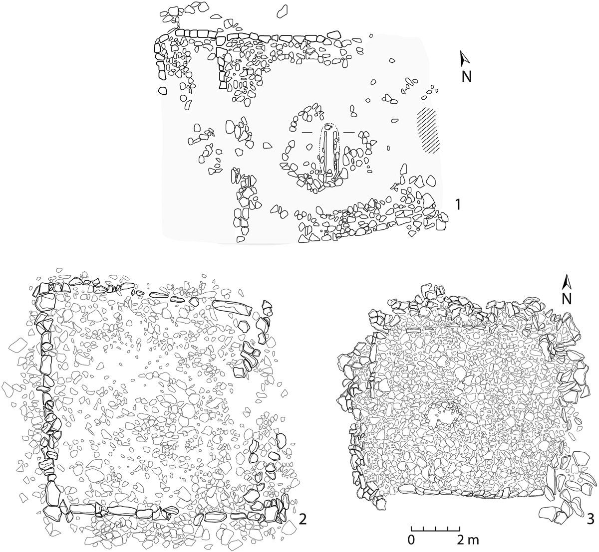