


During the medieval period and well into the 16th century, western Somaliland was part of a series of Muslim kingdoms which thrived thanks to the trade routes that connected the Red Sea with the interior of the Horn of Africa.
By Jorge de Torres
Keywords :
Somaliland, Medieval Period, Trade, Sultanate Of Adal, Archaeology, Nomad, Horn Of Africa, Caravan Station, Red Sea

Texte intégral
The Incipit‑CSIC archaeological project in Somaliland received funding by the Spanish Ministry of Economy and Competitiveness (HAR2013–48495‑C2–1‑P) between 2014 and 2017 and by the Palarq Foundation since 2017 to the present. The author’s research is funded by the European Union Research and Innovation Framework Programme Horizon 2020, through the Marie Curie Actions Individual Fellowships (Proposal 795442). The article would also like to acknowledge the work of all those involved in the preservation of the historical and archaeological Somali heritage, Somali and foreigners alike.
Introduction
The recent history of the Horn of Africa and more specifically Somalia is a troubled one, with recurrent periods of political instability, unrest, and violence which have had a deep impact on the development of proper archaeological research. Although the historical and archaeological information available for Somalia is more abundant that could be expected, it still suffers from serious problems of systematization and integration within regional historical dynamics.1 This lack of organized, comprehensive information affects our understanding of a series of key topics on the history of the region, including the functioning of trade networks in this area of the Red Sea, the arrival and spread of Islam in Africa, and the emergence of medieval Muslim kingdoms in the Horn from the 10th century onwards.
Fortunately, not all of the Horn of Africa has been equally affected by political instability and in some regions, archaeological research is currently providing new data about these and other important topics. That is the case of Somaliland, a region which seceded from Somalia in 1991 and has declared itself independent since then. Although not recognized internationally, it has achieved a high degree of political stability which has allowed some research initiatives in the last decades,2 including the discovery of the impressive Neolithic paintings of Laas Geel.3 In 2015, a long-term project was launched by the Institute of Heritage Sciences from the Spanish National Research Council (Incipit‑CSIC), which for the moment has conducted six fieldwork campaigns, most of them in the western half of Somaliland.
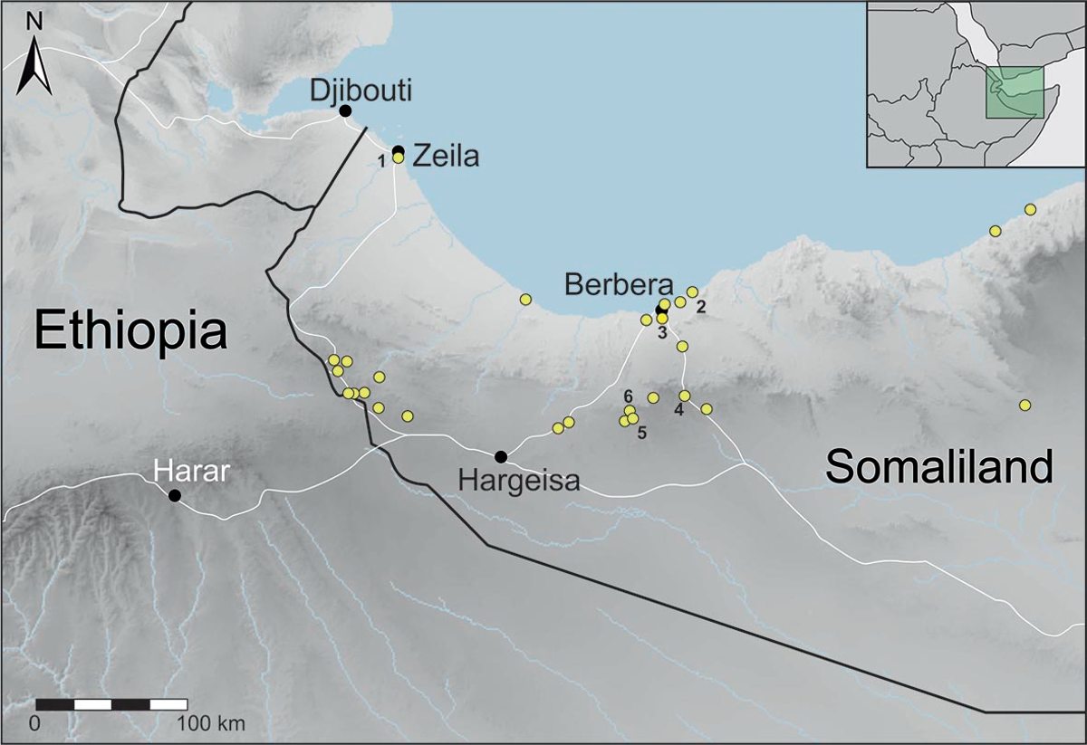
The Incipit‑CSIC project was originally planned as a two-pronged research project to analyze both sides of the international trade in East Africa – the second focus being Mozambique – and with a special interest on the interactions between local communities and foreign traders.4 During the past six years, the Incipit‑CSIC project has documented extensively 26 sites of different time spans, with small-scale excavations conducted in seven of them; as well as hundreds of other minor archaeological remains, from cairns to nomads’ mosques, contemporary ruins, and lithics scatterings (fig. 1). The publication of the results of the project is presenting for the first time a comprehensive overview of the archaeology of this region of the Horn, integrating it in wider political, cultural and economic networks.5 The project has also evolved overtime to focus on two specific historical periods: Antiquity, with the excavation of the important site of Heis,6 and the Middle Ages, the period which most of the sites have been chronologically ascribed to. This paper summarizes the most important outcomes for the medieval period, presenting some of the most relevant archaeological sites and analyzing a complex world of interactions between foreign trades, nomadic communities, and the inhabitants of the urban centers that dotted the region between the 13th and 16th centuries.
Fig. 1 – Map of Somaliland showing the sites documented by the Incipit‑CSIC team from 2015 to 2019, marking the sites described in the paper; 1: Zeila; 2: Siyaara; 3: Farhad; 4: Fardowsa/Sheikh; 5: Qalcadda; 6: Iskudar (Incipit‑CSIC project).
.")
Trade in the Middle Ages: the geographic and political context
Although much still needs to be understood about the social, economic, and political contexts of trade in Somaliland during the medieval period, there are two areas of knowledge that can help us set the framework in which this trade took place: the geographical context that regulates nomadic annual displacements and seasonal trade fairs, and the political context that favored the development of trade routes and provided a safe environment and infrastructures for the caravans. Regarding the geography, trade-in Somaliland can be conducted between October and April, when the monsoons favor the arrival of ships at a moment when nomads are concentrated close to the coast.7 In April, as the rain starts to fall, nomads move to the south to take advantage of the pastures of the Ogo mountains and the Haud, and the coast becomes deserted at a moment when the monsoon winds make sailing in the Red Sea a dangerous enterprise. These two major south-north movements (fig. 2) set the geographic framework and the seasonal rhythm of the trade in the region and have been key to interpreting the archaeological evidence for trade and reconstructing the materiality of coastal commerce.
Fig. 2 – Map of the seasonal displacements of nomads and merchants in Somaliland (Incipit‑CSIC project).
.")
Fig. 3 – Distribution of the main polities during the medieval period in the Horn of Africa (Incipit‑CSIC project, adapted from Braukämper 2002).
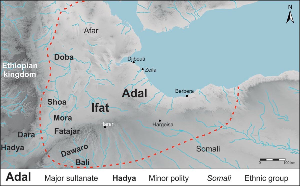
With respect to the historical context, the history of Somaliland and the southern half of the Horn of Africa in general during the 11th to the 16th centuries has been reconstructed through a significant corpus of Arab, Ethiopian, Chinese, and European texts,8 while the incorporation of archaeological and epigraphic data has only happened recently.9 This corpus includes Ethiopian royal chronicles, texts from Portuguese travelers such as Joao do Barros, Francisco de Álvarez, or Duarte Barbosa or a number of Muslim texts from Al‑Idrīsī, Abul Fida, Abū‑l‑Fidā’, Ibn Baṭṭūṭa or Arab‑Faqi, among many others, and allows to present a relatively precise overview of the history of the region in the medieval and early modern periods. According to authors like Trimingham or Cuoq,10 during the 9th century, the region saw the appearance of a number of small Muslim principalities to the south and east of the Ethiopian highlands, led by the state of Shoa (fig. 3). Since the 13th century, most of these polities were controlled first by the sultanate of Ifat (1285‑1415) and later by the sultanate of Adal (1415‑1577), which attempted to unify the different groups and principalities under their rule. The process of consolidation of these Muslim states led to increasing clashes with the neighboring Christian Ethiopian kingdom to the north, in a conflict which by the 16th century had clear connotations of a jihad. During the second half of the 16th century and after almost overcoming the Abyssinian kingdom, the sultanate of Adal collapsed due to a combination of military defeats, the decline of trade due to the Portuguese blockage of the Red Sea and the invasion of the Galla (a derogative name for the Oromo) groups from the south.
.")
Although there is no doubt that the dramatic events of the 14th to 16th centuries were fundamental to the development of the Horn of Africa as we currently know it, focus on the military and religious aspects has diminished alternative views of the history of the region. One of these alternative perspectives is the process of state-building undertaken by the successive rulers of the Muslim sultanates, which is still very poorly understood. Only recently new research on the written sources is paying a closer look into the reconstruction of the political, cultural, and economic parameters in which these states existed.11 Archaeologically speaking, some research has been carried out in the past on medieval Muslim sites such as Abasa or Amud,12 but recent research has been mostly focused on the arrival, expansion, and consolidation of Islam in the region rather than on the ways the medieval states organized themselves and controlled the population and economy of their territories.13 For the Incipit‑CSIC project, the analysis of statehood becomes fundamental to understanding some key aspects such as the organization of trade routes, the interactions between nomads and urban dwellers or the advance of urbanization. At the same time, the outcomes of the archaeological research have started to fill some gaps about the functioning of the medieval states in the eastern and southern regions of the Horn.
The archaeological context
Coastal sites
As mentioned previously, trade-in Somaliland was the result of the activity of three main groups – foreign merchants, nomadic groups and urban dwellers – which interacted at different levels from the coastal trading posts to final destinations inland. These three groups were all fundamental to the success of commerce, but archaeological evidence of their interactions has been elusive so far and is just beginning to be properly documented. Of course, trade is one of the key activities in the Red Sea, and Somaliland is not an exception – simply less studied so far. References to trade go as far back as the Periplus of the Erythrean Sea which describes several trading posts in Somaliland of which two have been identified so far: Avalites (modern Zeila) and Xiis.14 For the moment, only the second has yielded archaeological material.15 The paragraphs 7 to 12 of the Periplus describe the trading posts as meeting points where trade could be conducted with local groups, often in a context of mistrust between the two. All the places are described as market towns, but the descriptions refer only to strategic places to anchor and trade, never to permanent settlements. This situation seems to have been the norm in Somaliland, making this region an exception in East Africa and the Red Sea where urban centres seem to have been the logical outcome of prolonged trading activities.
According to the Arab and Portuguese texts, for the medieval and early modern periods, only three trading ports are considered permanent: Zeila, Berbera, and Maydh, the later consisting of just a small cluster of huts.16 Only Zeila could be considered a proper town, although it was undoubtedly an important one: references concur in describing it as the main trading post for all products from both the Christian and Muslim kingdoms, a cultural and religious hub, and, for some time, the capital of the sultanate of Adal.17 The city also had strong symbolism for the Muslims of the Horn of Africa as the place where the last sultan of Ifat, Saad ad‑Din, was defeated and killed, causing a deep impact on the local Muslim communities which contributed to the launching of a jihad against the Christian kingdom of Ethiopia.18
Unfortunately, little is left of the medieval remains of this important settlement and no systematic archaeological research has ever been conducted in the site. The most comprehensive study on this town is that of Fauvelle‑Aymar, who in two visits to the site dug three test pits along the coast and identified several archaeological remains which could be dated in the medieval period.19 These first survey and test pits yielded mostly modern materials from the 16th to the 19th centuries, while further test pits undertaken in the oldest part of the town provided older materials dated to the 13th and 14th centuries, results confirmed by a later visit to the site by the Incipit‑CSIC team in 2015.20 Currently, this limited archaeological research prevents us from understanding the urban structure and the historical trajectory of the city. Moreover, Zeila can be considered an exception in the trading system of Somaliland, where most of the exchanges took place either on beaches or in open spaces, near caravan stations or the aforementioned towns.21 Of these sites, Siyaara, is especially relevant, as it defines a type of settlement specific to the Somaliland region and provides comprehensive information about the characteristics of trade during the historic period.
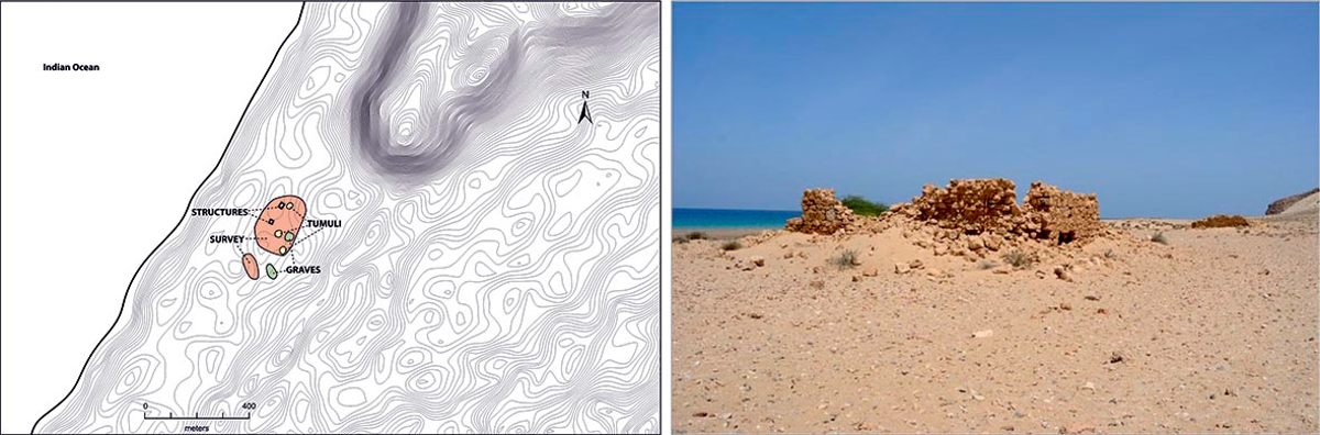
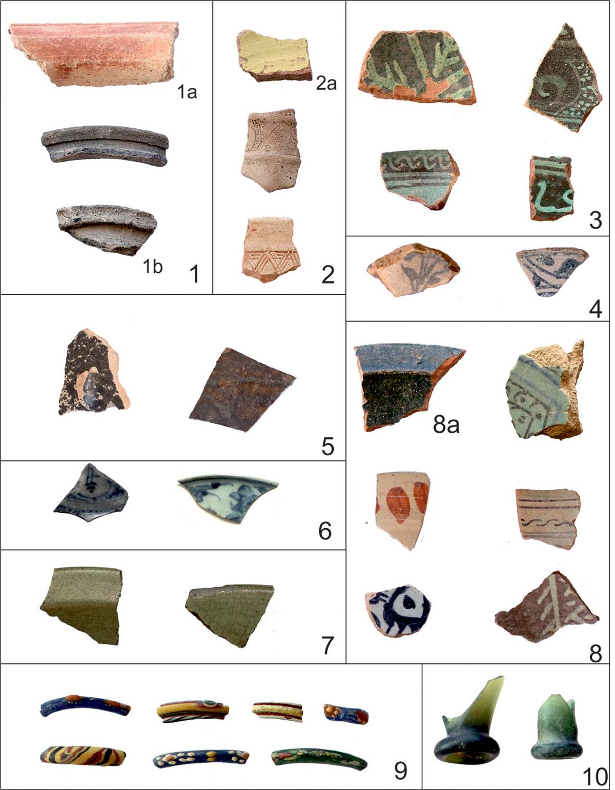
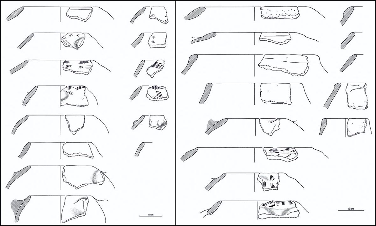
Located on a beach 33 kilometers west of Berbera, Siyaara is strategically situated close to a well and a rocky outcrop which no doubt acted as a landmark for sailors and has been used as harboring place at least until the early 20th century.22 It consists on a large scattering of imported materials and animal bones extending for more than one kilometer along the beach and occupying an area of about 12 hectares (fig. 4). Although two small buildings and a number of tombs and burial mounds have been identified across the site, it is clear that Siyaara was a place occupied seasonally; as its own name indicates (siyaaro is a Somali word that refers to an annual pilgrimage to a holy place where an ancestor is buried). Chronologically speaking, the thousands of fragments of imported materials at Siyaara indicate recurrent use of the site since at least the 11th century and up to an undetermined period around the 16th to 17th centuries – that is, the end of the Adalite period and its immediate aftermath (fig. 5).23 Local pottery is very scarce, as can be expected from nomadic groups, and in many cases can be identified as belonging to incense burners.
Fig. 4 – Plan of Siyaara, left, and view of the two buildings at the site, right (Incipit‑CSIC project).
.")
Fig. 5 – Imported materials found in Somaliland, not at scale; 1: Indian pottery (1a: Indian red polished ware, 1b: kitchen ware); 2: Yemen pottery (2a: Yemeni yellow ware); 3: green on green underglazed wares; 4: blue and white underglazed pottery; 5: Martaban stoneware; 6: blue and white Chinese porcelain; 7: Chinese celadon; 8: other glazed and painted wares (8a: speckled ware); 9: glass bangles probably from Syria/Egypt/Turkey; 10: glass bottles, same provenance (Incipit‑CSIC project).
; 2: Yemen pottery (2a: Yemeni yellow ware); 3: green on green underglazed wares; 4: blue and white underglazed pottery; 5: Martaban stoneware; 6: blue and white Chinese porcelain; 7: Chinese celadon; 8: other glazed and painted wares (8a: speckled ware); 9: glass bangles probably from Syria/Egypt/Turkey; 10: glass bottles, same provenance (Incipit‑CSIC project).")
The site of Siyaara is especially relevant as a canonical example of a temporary coastal trading post, but it is reasonable to think that similar meeting points were established close to the few permanent settlements which existed during the medieval period. The Incipit‑CSIC project has identified one of these sites in the outskirts of Berbera, which in the 15th‑16th centuries was a minor but permanent settlement by the coast.24 The site, named Farhad, is located 3 kilometers to the south of the town and spreads along an area of 5 hectares at the foot of a prominent rocky hill. It has been interpreted as a seasonal trading point which was related to Berbera, a permanent settlement. As in the case of Siyaara, the place is littered with thousands of imported pottery sherds, storage containers, glass pieces and animal bones, but in this case no permanent structures or tombs have been found. Although some of the imported materials found in Farhad can be dated to the 12th-13th centuries, the bulk of the material dates to between the 14th and early 17th centuries, coinciding with the Adal sultanate (1415‑1577) and the first references to Berbera as an important post on the coast of Somaliland.25
Although more intensive research needs to be carried out on coastal medieval sites in Somaliland, some conclusions can be drawn from the existing evidence. The most widespread and enduring system of trade – with the exception of Zeila – consisted of direct exchange between nomads and foreign traders, continuing a tradition which can be traced at least from Antiquity. This system was slightly modified during the 15th and 16th centuries, when some small but permanent settlements appeared – Berbera and Maydh –, perhaps due to the influence of the sultanate of Adal and the political and economic changes which took place in that period. However, these small settlements did not evolve into proper towns until the 19th century and in a completely different political context.
Sedentary settlements
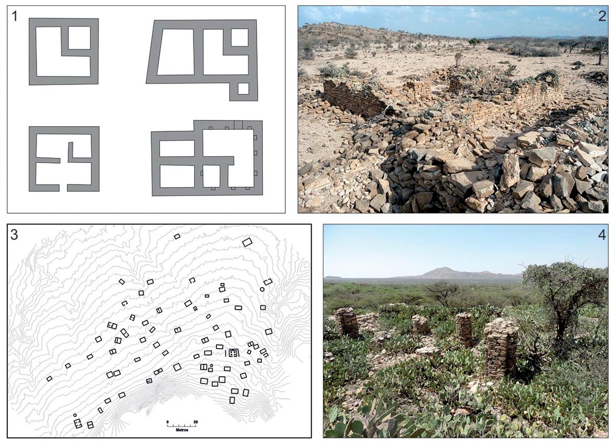
Contrary to the coast of Somaliland, the medieval chronicles do not make many references to the characteristics of settlements in western Somaliland, as they focus mostly on the region of Harar and other areas bordering the Christian kingdom of Ethiopia. The only reference to towns in the interior of Somaliland comes from the Spanish traveler Luis del Mármol,26 who in his Description of Africa (16th century) lists six cities, none of which have ever been identified archaeologically. Arab or Ethiopian sources refer generically to the destruction of settlements during the repeated raids and invasions of Ethiopian armies into the territory of Ifat or Adal,27 but without giving accurate details about the location and characteristics of these sites. This situation contrasts sharply with the available archaeological data, which show a widespread presence of settlements of different sizes and functions all along the Ogo mountains and the Borama area (fig. 6), where climate conditions favor a permanent occupation of the territory. The ruins of medieval settlements were described in the 19th century by the earliest travelers across Somaliland,28 but the first archaeological study of these sites was conducted by Curle29 only in 1934, and since then sporadic surveys30 have increased the number of known sites to close to twenty. In 2015 and with the beginning of the Incipit-CSIC project, a comprehensive study of these important sites has been launched, including the recording and mapping of around 20 sites, the excavation of test pits in seven of them, and the collection of a significant amount of pottery and other archaeological materials to reconstruct, for the first time, the material culture of the sedentary communities of medieval Somaliland.
Fig. 6 – Distribution of medieval sites in the interior of Somaliland and the immediate Ethiopian territory (Incipit‑CSIC project).
.")
This systematic research is starting to unravel a much more complex world than initially expected, with significant differences regarding the functions, sizes, and main economic activities of these sites (fig. 7). Settlements show a clear hierarchy based on size, with the bigger ones having more than 200 houses and more than one mosque, while other sites are hamlets of just five or six houses.31 Moreover, not all sites are actually settlements: the Incipit‑CSIC surveys have identified a wide typology of sites which includes caravan stations, religious centers and one fortress.32 Regardless of their function, all the sites share common characteristics: lack of urban planning and protective walls, scattered houses built with flat stones without any binding and a general absence of public buildings with the exception of mosques. Material culture is also very uniform, consisting of coarse hand-made pottery following a limited number of types (fig. 8). No local pottery of high quality has been found so far, contrary to the situation in the Christian kingdom of Abyssinia, probably due to an easier access to imported pottery given to the closeness to the Red Sea and Indian Ocean trade routes.33 However, it seems that not all the settlements were involved in trade activities: a number of sites surveyed around the Borama area show a very low proportion of imported materials and emplacements which take advantage of rivers and – relatively – good soils, thus pointing to an agrarian vocation. Trade hubs, on the contrary, seem to have been placed at strategic points on trade routes, especially close to the edge of the Ogo mountains range where they would constitute the last or first stop for caravans crossing the desert plains on their way to or from the coast.
Fig. 7 – Constructive characteristics of medieval sites in the interior of Somaliland; 1: sketches of houses in Amud (adapted from Huntingford 1978); 2: view of the site of Dameraqad; 3: plan of Hasandile; 4: mosque at Abasa (Incipit‑CSIC project).
; 2: view of the site of Dameraqad; 3: plan of Hasandile; 4: mosque at Abasa (Incipit‑CSIC project).")
Fig. 8 – Local pottery from Amud, left, and Qorgab, right (Incipit‑CSIC project).
.")
The important town of Fardowsa constitutes the best-known example of these trade hubs. The site is strategically situated on the outskirts of the village of Sheikh, at the end of the so-called Sheikh Pass, which connects Berbera with the interior of Somaliland. The importance of the Sheikh Pass is attested by early colonial accounts which also make reference to the existence of a tariqat or religious center here, to which the current name of Sheikh probably refers.34 Surprisingly considering the importance of the ruins of this major settlement, its strategic location, and the references to a huge town and graveyard made by Swayne,35 nobody paid attention to the site until the 2010s, when Fauvelle‑Aymar and Hirsch visited it briefly and described its main characteristics.36 In 2015 it was also visited by the Incipit‑CSIC team, which in 2016 conducted two test pits and a full survey of the site (fig. 9).37
Fig. 9 – Excavation of house at Fardowsa/Sheikh (Incipit‑CSIC project).
.")
The ruins extend for about one kilometer NW-SE to the north of the modern village of Sheikh, although its eastern limit is difficult to assess as the expansion of the modern village has severely affected many of the structures. However, the central part of the site is very well preserved, with some buildings surviving to 1.5 meter above ground. The site follows the canon of all medieval sites in western Somaliland: scattered and isolated squared houses with one or more partitions built with flat stones, scattered without any evidence of urban planning although there is a higher concentration of buildings to the east of the site. No mosques were identified during the survey due to the significant amounts of rubble and the bushes that covered all the buildings, although no doubt these existed. The imported materials recovered during the surveys suggest a chronology between the 13th to the 16th centuries, and include celadon and Chinese blue and white porcelains, glazed pottery of different origins and other wares such as Yellow yemenite (mustard ware) sherds. Cowries and glass shards were also common, including small perfume bottles and bangles. The excavations, on the contrary, did not yield any chronologically conclusive materials, and the general impression of the interior of the houses pointed to a progressive abandonment of the site. Animal bones were, on the contrary, very abundant and consisted mostly in ovicaprines, with a very low proportion of camels, cattle and wild species.38 The mills found throughout the site and in the interior of the houses show the existence of agriculture, necessary to sustain a settlement of respectable size and whose population would see periodical increases during the trading season.
The strategic position of Fardowsa, its size and the amount of imported materials mark this settlement as one important hub in the network of sites which structured the medieval trade networks in western Somaliland. It also explains the end of the site at an unknown moment in the late 16th or early 17th centuries, according to the pottery found in the site. The reasons for the abandonment seem to be directly related to the disturbance of trade routes caused by the Portuguese blockage of the Red Sea and the collapse of the Adal sultanate, which had provided a safe environment for trade.
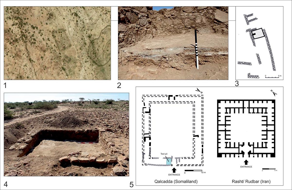
An evidence of this interest of the state in securing commerce can be appreciated in the exceptional site of Qalcadda, a caravan station built following a Middle East design which was surveyed and tested in 2016 by the Incipit‑CSIC team (fig. 10).39 The site of Qalcadda (from the Arabic word qalāt) lies about 50 kilometers to the west of Sheikh, very close to the Jerato Pass, one of the most important passes that connected the coast with the interior of Somaliland.40 The site consists of a rectangular enclosure (55×90 m) with thick walls around one meter high made of dressed stone and corners defended by round bastions; a smaller square building directly to the south and an artefact scatter covering around 0.8 hectare where a significant number of imported materials – pottery, porcelain, glass, cowry and soft stones – were recovered. It has been interpreted as a market area. Around these three main features a score of tombs was also found, in some cases dug into the previous buildings.
Fig. 10 – The caravan station of Qalcadda; 1: satellite image of the site (Google Earth); 2: detail of the several plaster floors of the excavated area (Incipit‑CSIC project); 3: plan of the east nave and the test pit (Incipit‑CSIC project); 4: test pit (Incipit‑CSIC project); 5: comparison between Qalcadda and a Persian caravanserai (Mansouri, Edgü, Şalgamcioğlu 2015).
; 2: detail of the several plaster floors of the excavated area (Incipit‑CSIC project); 3: plan of the east nave and the test pit (Incipit‑CSIC project); 4: test pit (Incipit‑CSIC project); 5: comparison between Qalcadda and a Persian caravanserai (Mansouri, Edgü, Şalgamcioğlu 2015).")
A test pit and the careful mapping of the smaller building documented a square structure with an ample, central courtyard and partitioned rooms around it, defining a classical Middle East caravanserai plan. The excavation of a small trench of 2.5×4 meters in the main room of the building, next to what seems to be its main access, showed a series of four consecutive lime floors which evidenced a careful maintenance of the building.41 A radiocarbon date was obtained from the penultimate floor, offering a chronology of 318±28 BP (D‑AMS‑015989 [CAIS 24947]; calibrating to 1486‑1646 AD), situating the most likely use of the room at some point during the 16th century coinciding with the heyday of the sultanate of Adal.42 This chronology is reinforced by the materials collected throughout the site and during the excavation, which never go beyond the 17th century.
As happens with Fardowsa, the decline of Qalcadda seems to be directly related to the downturn of commerce and the dismantling of the umbrella provided by the Adal state. What makes Qalcadda exceptional is not just its design, with Middle East influences, which evidences the rooted and intense relationships between the Horn of Africa and that region. Its importance derives specially from its symbolism as a state initiative. The complex of Qalcadda (fort, caravan station and market area) is isolated, and it seems unlike that it was maintained by the small villages that can be found in its vicinity. Qalcadda would likely be kept by the state or other polity and would then be the first hint of the strategies employed by the sultanate of Adal to reassert its control over the region, either directly or through proxies.
Nomads
The archaeology of nomadism in Somaliland – and by extension, Somalia – is contradictory in many aspects. Although the Somalis are recognized as an eminently nomadic society and there has been considerable research on their lifestyle, little is known about their material past.43 Even basic aspects of their rich material culture are poorly known, with the only ethnographic account dated in the 1930s.44 Regarding the origins and the history of the Somalis, most of the data comes from oral traditions or references from the later written texts.45 Although some work has sought to analyse the territory and organization of the Somali clans during the 16th century, we have very little information about the nomadic communities of Somaliland before that century.46
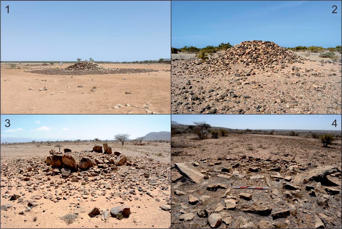
22Of course, as happens elsewhere, the perishable character of most nomadic material culture has centered attention on their funerary monuments, very abundant in Somaliland (fig. 11). The widespread presence of cairns and other types of tomb was noticed by the first travelers crossing the region,47 and since then drawings and descriptions of these types of structure are common in the publications of these explorers.48 However, almost no comprehensive studies have been conducted on these funerary monuments, leaving aside a preliminary typology proposed by Chittick49 and a comprehensive documentation of one cairn field in Elayo (in the coastal easternmost side of Somaliland, close to the border with Puntland), whose results were never published.50 Although references, descriptions and in some cases brief reports of excavations of cairns and other tombs are common in the archaeological literature,51 only recently have more systematic studies been launched of these archaeological remains which will allow, as work progresses, a better understanding of their chronology, distribution and sociocultural implications.52
Fig. 11 – Funerary monuments in Somaliland; 1: simple cairn; 2: cairn surrounded by stone floor; 3: crown-like tombs; 4: cruciform tomb (Incipit‑CSIC project).
.")
The first point to note is their exceptionally complex typology. So far the only attempt made to classify them has defined 14 types of cairns, graves and other funerary structures.53 However, later surveys by Incipit‑CSIC and other research teams have identified several more types, including tombs of cruciform shape and stelae standing at the four ends of the cross,54 “crown-like” tombs55 and many variations on the types described by Chittick, including the use of stones of different colours to achieve impressive chromatic effects or the placing of stelae at the base of the cairns. To some extent, this huge variety of funerary structures can be explained by chronological or regional factors, but even sites with a short chronology such as Heis show a remarkable variety of types of burial. Regarding the chronology, the oldest structures to be excavated can be dated to the Neolithic (4th‑2nd millennium BC),56 while other structures have been ascribed to the 1st century AD,57 but many of them undoubtedly belong to the 2nd millennium AD.58 Although funerary structures constitute a majority of the archaeological evidence for nomadic communities, they are not the only evidence: mosques are also very common for the medieval and later periods, consisting of simple outlines of a mosque plan made with stones. Less common is a type of circular, wheel-like stone structure consisting of big circles partitioned by radial walls and a smaller circle in the middle. Although none of them have been documented in detail, they are easily identifiable through satellite images and recall very strongly the camel camps made with thorns documented by ethnographic work, where the herders use the central space to sleep and the herds are distributed in the radial spaces according to their owners.59
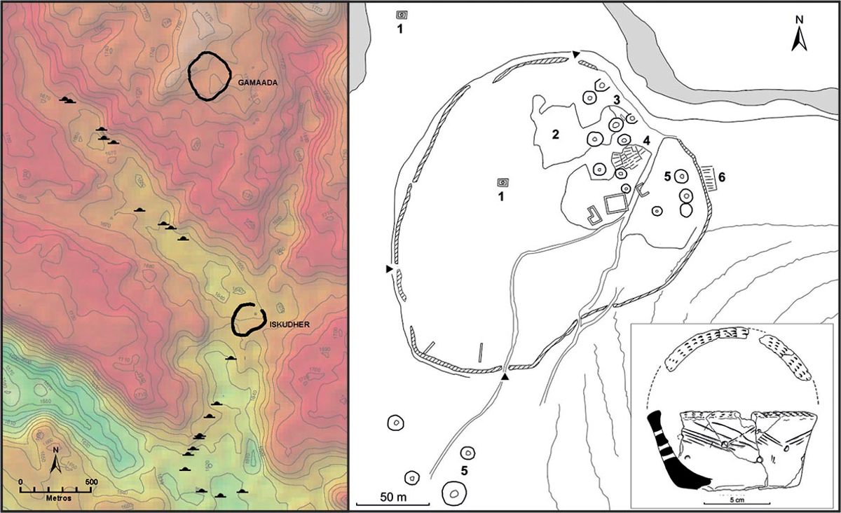
Moreover, the research of the Incipit‑CSIC team has found a type of archaeological site which constitutes an exceptional reference for the understanding of the nomadic landscape during the medieval period (fig. 12).60 The site, named Iskudar (“aggregation”, “mixing” or “combination” in Somali) is situated at a low elevation at the confluence of three wadis, very close to the edge of the Ogo mountains before reaching the Guban coastal plains. The watercourses that give access to the place are dotted with cairns which act as a kind of monumental avenue to the site itself, an oval space of about three surrounded by a low stone wall with a perimeter of almost 700 meters, made of two rows of roughly hewn stones or small stelae. The interior of the site is largely covered with rubble and structures are difficult to identify, with the exception of the north-western part which has relatively well-preserved funerary structures – stone rings, small cairns and clusters of cists. Immediately to the south of these features the walls of four rectangular structures were located, including one with large dimensions which could correspond to a mosque.
Fig. 12 – Location, left, and plan, right, of Iskudar; 1: cruciform tombs; 2: areas covered in rubble; 3: area with remains of feasting activities; 4: cist cluster; 5: structures; 6: cist cluster (Incipit‑CSIC project).
.")
The excavation of several test pits in the area with a higher accumulation of structures showed a denser presence of finds to the north, becoming sparser towards the south.61 The majority of these finds were zoological remains which were lying on the original surface of the structures, and consisted mostly on bones of goats and sheep, with a good representation of cattle and camels and a low presence of wild animals in the sample. In addition to the animal bones, two fragments of wheel-made pottery and a score of local handmade pottery decorated with incised designs, including an incense burner mixed with bones which points to feasting activities probably related to the burials. The 14C dates collected at two of the test pits offered a date of 827±24 BP (D‑AMS‑015990, cal. 1166‑1260 AD) for locus 3 and 663±20 BP (DAMS‑015991, cal. 1276‑1393 AD) for locus 5.62 The materials found during the survey were coherent with these dates, including a faceted rim from an Indian wheel-turned cooking pot, which has a long chronology from the 9th to the 16th centuries AD,63 and a fragment of marvered glass from a perfume bottle, a typical decoration of the Ayyubid period in Egypt, with a heyday in the 12th-13th centuries AD.64
Regarding the interpretation of the site, it seems clear that its complexity goes far beyond its use as a cemetery, and was probably related to recurring feasting activities in the burial area as well as the burial of individuals over time. The interpretation of the faunal remains as the remains of funerary rituals involving banqueting has support in ethnographic parallels both in Somali traditions65 and from neighboring groups such as the Afar.66 The existence of these “pagan” rituals in the later Middle Ages sits with the proposed date for the beginning of Islamisation around the end of the 12th or beginning of the 13th centuries which would make the existence of a “pagan” sanctuary during the first centuries of the 2nd millennium AD logical.67 Regarding the end of the use of the site, it could be related to the rise of the Adal sultanate at the beginning of the 15th century, when Islam was already well established in the country.
Conclusions: a business of three
The research conducted in Somaliland during the last five years has unraveled a much more sophisticated world than initially expected, especially with regards to the medieval period. The tentative interpretative framework based on the interactions between two communities – local groups and traders – has been substituted by a more complex pattern which involves at least three main groups: settlement dwellers, pastoralist nomads and foreign merchants. The participation of these three groups in trade was necessary to structure trade within the Horn of Africa, and to link it reliably to the wider Indian Ocean and Red Sea international routes. The archaeological evidence of these communities and their interactions have been briefly presented in this paper, and future research will no doubt add depth to this proposal, helping us to understand the multiple layers in which these interactions took place.
In fact, this first level of analysis – three communities collaborating in a specific economic activity – is subsumed within a higher level of relations between two very different lifestyles: that of the nomadic groups that wandered around the region and the one defined by urban dwellers, either at inland settlements or in Zeila. Although these two worlds established two different perceptions of territory, identity and shared interests, the archaeological evidence found so far does not point to antagonism between the groups, but rather to a coordination and agreement in key areas such as trade or war. Finally, at a third, higher level, the Incipit‑CSIC project is starting to clarify the role of the state in the whole system, described in the written sources but difficult to track in the archaeological record.
The analysis of these three levels of reality – communities, lifestyles, state structures – in Somaliland is defining a somehow atypical world within the Red Sea, whose singularity can be perceived in different aspects of reality. The first one is the aforementioned relation between nomads and urban dwellers, usually perceived as a dichotomy and often as an antagonistic position. In the case of Somaliland coast, that dichotomy exists but does not seem to lead to antagonism, but to an effective cooperation between both groups. In this case the key question is not only to understand how these two completely different worlds occupied the same territory, but under which premises they coexisted, collaborated and established shared interests.
A second set of research questions comes from the analysis of the urbanization processes – or lack of – which took place in Somaliland during the medieval period. Unlike most other places along the Red Sea and in East Africa (including other areas of the Somali coast), recurrent and very active trade on the coast of Somaliland did not lead to the emergence and development of urban centers, again setting this region apart from the neighboring historical processes. Of course, the lack of coastal towns could be explained by climate, but only partially: during the colonial period, towns such as Bulhar were founded ex novo overcoming climate conditions,68 and others like Berbera evolved from important seasonal trading posts into towns of respectable size. The reasons for this anomaly still need to be clarified, but undoubtedly did not affect the ability to organize trade efficiently. On the other hand, the sudden disappearance of urban centers in the interior after the 16th century needs to be addressed. The obvious explanation would be a collapse theory based on the combination of military defeats and trade blockage, but the term collapse should actually be avoided: so far, archaeology does not show a traumatic end of these settlements, but a progressive abandonment without evidence of violence. It would be more appropriate to talk about a reorganization of the trade system in a new context in which state structures and urban centers were no longer efficient. Moreover, the oldest towns such as Zeila and Harar endured, although diminished, acting as trade hubs until the 19th century.
Another aspect which needs reassessment is the analysis of conflict in the medieval history of Somaliland. Traditionally, this history has been directly related to the clashes between the Christian kingdom of Abyssinia and the successive Muslim polities to the south and southeast of the Horn. However, this almost continuous state of war does not find, so far, any correlation in the archaeological evidence. To this moment, evidence of conflict is scarce in Somaliland: the overwhelming majority of the settlements studied so far do not have walls and their abandonment seems to have been progressive and pacific. On the other hand, it is difficult to reconcile the idea of permanent military conflict (ever present in the historical texts) with the stability required for the trade which flourished throughout the Middle Ages. This lack of coherence between historical texts and archaeological data needs to be addressed in the near future, and will probably lead to a more balanced view between both sets of information.
Finally, a similar contradiction between texts and archaeology can be observed in relation to the role and structure of the medieval states in the Horn of Africa, with written evidence providing a rich amount of data not paralleled by the archaeological evidence. In this case, however, the research conducted by the Incipit‑CSIC team is shedding some light on the material strategies used by the Muslim states to reassure and extend their control over the territory and the communities occupying it. Sites such as Qalcadda show the presence of state initiatives aimed at controlling and protecting economic activities, while the presence of numerous religious centers such as Dameraqad69 and the progressive disappearance of indigenous traditions seen in sites such as Iskudar would be explained by the use of Islam as a binding force which reinforced the control of the state over the population.
These topics and questions are just some of many that need to be addressed to understand the social and historical dynamics of the Somaliland region and its material expressions. The Incipit‑CSIC project, while providing an increasing corpus of data which complements existing information, is also helping to redefine some of the traditional views of the medieval sultanates of the Horn of Africa. Although much more research still needs to be done, these five years of work show very explicitly that archaeology not only provides a material base to complement historical narratives: it can actually have a leading role in deciphering the sophisticated strategies used in the construction of medieval Somaliland.
Bibliographie
Ancient sources
Periplus of the Erythrean Sea, transl. W.H. Schoff, New York, Longman Green and Co., 1912.
Sihab ad‑Din Ahmad bin Abd al‑Qader, Futūḥ al‑Ḥabaša. The conquest of Abyssinia, transl. P.L. Stenhouse with annotations of R. Pankhurst, Hollywood, Tsehai Publishers, 2003.
Modern sources
Braukämper 2002: U. Braukämper, Islamic history and culture in southern Ethiopia. Collected essays, Münster, LIT Verlag, 2002.
Burton 1894: R.F. Burton, First footsteps in East Africa, or an exploration of Harar, 2 vol., London, Tylston and Edwards, 1894 (memorial edition).
Cerulli 1931: E. Cerulli, “Documenti arabi per la storia dell’Etiopia”, Memorie della Reale Accademia Nazionale dei Lincei 6/4, 1931, pp. 39‑101.
Cerulli 1941: E. Cerulli, “Il sultanato dello Scioa nel secolo XIII secondo un nuovo documento storico”, Rassegna di Studi Etiopici 1/1, 1941, pp. 5‑42.
Chekroun 2013: A. Chekroun, Le “Futuh al-Habasa”: écriture de l’histoire, guerre et société dans le Bar Sa’ad ad‑din (Éthiopie, xvie siècle), PhD dissertation, Université Paris I Panthéon-Sorbonne, 2013 (unpublished).
Chittick 1992: H.N. Chittick, “Cairns and other drystone monuments in Somali regions”, in H.M. Adam, C.L. Geshekter (ed.), Proceedings of the first international congress of Somali studies, Chico, Scholars’ Press, 1992, pp. 35‑42.
Cros, Bernard, Joussaume 2006: J.‑P. Cros, R. Bernard, R. Joussaume, “Tumulus et pierres dressées dans la région de Las Geel (Somaliland)”, Afrique: Archéologie & Arts 4, 2006, pp. 109‑124, https://journals.openedition.org/aaa/1426 (accessed 22/01/2021).
Cros et al. 2017: J.‑P. Cros, X. Gutherz, J. Lesur, M.‑A. Ali, “Les monuments mégalithiques du Somaliland”, Afrique: Archéologie & Arts 13, 2017, pp. 43‑58, https://journals.openedition.org/aaa/994 (accessed 22/01/2021).
Cuoq 1981: J. Cuoq, L’Islam en Éthiopie des origines au xvie siècle, Paris, Nouvelles Éditions Latines, 1981.
Curle 1937: A.T. Curle, “The ruined towns of Somaliland”, Antiquity 11/43, 1937, pp. 315‑327.
Desanges, Stern, Ballet 1993: J. Desanges, E.M. Stern, P. Ballet, Sur les routes antiques de l’Azanie et de l’Inde. Le fonds Révoil du Musée de l’Homme (Heïs et Damo, en Somalie), Paris, Impr. F. Paillart, 1993.
Fauvelle‑Aymar et al. 2011: F.‑X. Fauvelle‑Aymar, B. Hirsch, R. Bernard, F. Champagne, “Le port de Zeyla et son arrière-pays au Moyen Âge. Investigations archéologies et retour aux sources écrites”, in F.‑X. Fauvelle‑Aymar, B. Hirsch (ed.), Espaces musulmans de la Corne de l’Afrique au Moyen Âge. Études d’archéologie et d’histoire, Paris/Addis Abebba, De Boccard/Centre français d’études éthiopiennes, 2011, pp. 26‑74.
Fauvelle‑Aymar, Hirsch 2011a: F.‑X. Fauvelle‑Aymar, B. Hirsch (ed.), Espaces musulmans de la Corne de l’Afrique au Moyen Âge. Études d’archéologie et d’histoire, Paris/Addis Abebba, De Boccard/Centre français d’études éthiopiennes, 2011.
Fauvelle‑Aymar, Hirsch 2011b: F.‑X. Fauvelle‑Aymar, B. Hirsch, “Muslim historical spaces in Ethiopia and the Horn of Africa: a reassessment”, Northeast African Studies 11/1, 2011, pp. 25‑54.
González-Ruibal et al. 2017: A. González‑Ruibal, J. de Torres, M.A. Franco, A.M. Ali, A. Shabelle, C. Martínez, K. Aideed, “Exploring long distance trade in Somaliland (AD 1000‑1900): preliminary results from the 2015‑2016 field seasons”, Azania 52/2, 2017, pp. 135‑172.
González‑Ruibal, Torres 2018: A. González‑Ruibal, J. de Torres, “The fair and the sanctuary: gathering places in a nomadic landscape (Somaliland, 1000‑1600 AD)”, World Archaeology 50/1, 2018, pp. 23‑40.
Gutherz, Cros, Lesur 2003: X. Gutherz, J.‑P. Cros, J. Lesur, “The discovery of new rock paintings in the Horn of Africa: the rock shelters of Las Geel (Republic of Somaliland)”, Journal of African Archaeology 1/2, 2003, pp. 227‑236.
Hornby 1907: M.L. Hornby, Military report on Somaliland, London, General Staff, War Office, Eyre and Spottiswoode, 1907.
Huntingford 1978: G.W.B. Huntingford, “The town of Amud, Somalia”, Azania 13/1, 1978, pp. 181‑186.
Insoll 2017: T. Insoll, “First footsteps in the archaeology of Harar”, Journal of Islamic Archaeology 4, 2017, pp. 189‑215, https://api.equinoxpub.com/articles/fulltext/35273 (accessed 22/01/2021).
Jönsson 1983: S. Jönsson, Archaeological research co-operation between Somalia and Sweden: report on a three-month visit to Somalia in 1982, Stockholm, The Swedish Central Board of National Antiquities, 1983.
Lewis 1955: I.M. Lewis, Peoples of the Horn of Africa: Somali, Afar and Saho, London, International African Institute, 1955.
Lewis 1961: I.M. Lewis, “The so-called ‘Galla graves’ of northern Somaliland”, Man 61, 1961, pp. 103‑106.
Lewis 1998: I.M. Lewis, Saints and Somalis: popular Islam in a clan-based society, London, Haan Associates, 1998.
Lewis 1999: I.M. Lewis, A pastoral democracy: a study of pastoralism and politics among the northern Somali of the Horn of Africa, Münster/Hamburg/Oxford, LIT Verlag/James Currey, 1999 (1st ed. Oxford University Press 1961).
Mansouri, Edgü, Şalgamcioğlu 2015: A. Mansouri, E. Edgü, M.E. Şalgamcioğlu, “Historic Persian caravanserais: climatic effects and syntactic configuration”, in K. Karimi (ed.), SSS10, 10th International Space Syntax Symposium. Proceedings of the 10th International Space Syntax Symposium, London, Space Syntax Laboratory, The Bartlett School of Architecture, University College of London, 2015, pp. 53.1‑53.12, http://www.sss10.bartlett.ucl.ac.uk/wp-content/uploads/2015/07/SSS10_Proceedings_053.pdf (accessed 22/01/2021).
Mármol‑Carvajal 1599: L. del Mármol‑Carvajal, Segunda parte y libro séptimo de la descripción general de Africa, Malaga, Juan Rene Editor, 1599.
Mire 2015: S. Mire, “Mapping the archaeology of Somaliland: religion, art, script, time, urbanism, trade and empire”, African Archaeological Review 32/1, 2015, pp. 111‑136.
Mussi 1984: M. Mussi, “Excavations in southern Somalia”, Nyame Akuma 24/25, 1984, p. 18, https://www.africanistarchaeology.net/1984 (accessed 22/01/2021).
Pankhurst 1961: R. Pankhurst, An introduction to the economic history of Ethiopia from early times to 1800, London, Lalibela House, 1961.
Puccioni 1936: N. Puccioni, Antropologia e etnografía delle genti della Somalia III. Etnologia e Paletnologia, Bologna, Nicola Zanichelli, 1936.
Swayne 1903: H.G.C. Swayne, Seventeen trips through Somaliland and a visit to Abyssinia, London, Rowland Ward “The Jungle” limited, 1903 (3rd ed.), https://library.si.edu/digital-library/book/seventeentripsth00sway (accessed 22/01/2021).
Révoil 1882: G. Révoil, La Vallée du Darror. Voyage au Pays Çomalis (Afrique orientale), Paris, Challamel Ainé, 1882.
Rougeulle 2015: A. Rougeulle (ed.), Sharma. Un entrepôt de commerce médiéval sur la côte du Hadramawt (Yémen, ca. 980‑1180), Oxford, Archaeopress, 2015.
Thesiger 1996: W. Thesiger, The Danakil diary: journeys through Abyssinia, 1930‑34, London, Harper Collins, 1996.
Torres 2017: J. de Torres, “Sherds of a kingdom: historical pottery of the Lake Tana region (northern Ethiopia)”, African Archaeological Review 34, 2017, pp. 225‑248.
Torres 2018: J. de Torres, “Against all odds: the history of archaeological research in Somaliland and Somalia”, Northeast African Studies 18/1‑2, 2018, pp. 271‑310, https://digital.csic.es/handle/10261/216289 (accessed 22/01/2021).
Torres et al. 2017: J. de Torres, A. González‑Ruibal, M.A. Franco, C. Martínez, K. Aideed, A. Shabelle, “Bulhar: a colonial town in Somaliland. Report from the 2017 excavations”, Nyame Akuma 87, 2017, pp. 55‑61, https://www.africanistarchaeology.net/s/Nyame-Akuma-Issue-087-Torres-2.pdf (accessed 22/01/2021).
Torres et al. 2018: J. de Torres, A. González‑Ruibal, M.A. Franco, A.D. Jama, “Medieval archaeology in Somaliland: the 2018 field season of the Incipit‑CSIC project”, Nyame Akuma 90, 2018, pp. 30‑35, https://digital.csic.es/handle/10261/216278 (accessed 22/01/2021).
Torres et al. 2020: J. de Torres, A. González‑Ruibal, C. Kleinitz, M.A. Franco, C. Martínez, A.D. Jama, “Excavation of a first century AD tomb in Heis (Somaliland): evincing long-distance trade contacts”, Nyame Akuma 91, 2020, pp. 30‑35, https://digital.csic.es/handle/10261/216276 (accessed 22/01/2021).
Trimingham 1952: J.S. Trimingham, Islam in Ethiopia, London, Oxford University Press, 1952.
Whitcomb 1983: D.S. Whitcomb, “Islamic glass from Al‑Qadim, Egypt”, Journal of Glass Studies 25, 1983, pp. 101‑108.
Notes
1 Torres et al. 2018.
2 Fauvelle‑Aymar, Hirsch 2011a; Mire 2015.
3 Gutherz, Cros, Lesur 2003.
4 Torres 2018, pp. 292-293.
5 González‑Ruibal et al. 2017; González‑Ruibal, Torres 2018; Torres et al. 2017; Torres et al. 2018.
6 Torres et al. 2020. See also Fernández Fernández, González‑Ruibal, de Torres, this volume.
7 González‑Ruibal, Torres 2018, pp. 25‑26.
8 Cerulli 1931; Cerulli 1941; Trimingham 1952; Cuoq 1981; Braukämper 2002.
9 Fauvelle‑Aymar, Hirsch 2011b.
10 Trimingham 1952; Cuoq 1981.
11 Chekroun 2013.
12 Curle 1937; Huntingford 1978.
13 Fauvelle‑Aymar, Hirsch 2011a; Fauvelle‑Aymar, Hirsch 2011b; Insoll 2017.
14 Periplus of the Erythrean Sea (transl. Schoff 1912), pp. 24‑26.
15 Torres et al. 2020.
16 Trimingham 1952.
17 Pankhurst 1961, pp. 346‑349.
18 Cuoq 1981, p. 152.
19 Fauvelle‑Aymar et al. 2011, pp. 32‑35.
20 Fauvelle‑Aymar et al. 2011, p. 49.
21 González‑Ruibal, Torres 2018, p. 26.
22 Hornby 1907, p. 32.
23 González‑Ruibal, Torres 2018, p. 30.
24 González‑Ruibal, Torres 2018, pp. 29‑30.
25 Pankhurst 1961, pp. 350‑351.
26 Mármol‑Carvajal 1599, book 10, sheet LX.
27 Cuoq 1981, p. 152.
28 Burton 1894 ; Swayne 1903.
29 Curle 1937.
30 Mire 2015; Fauvelle‑Aymar, Hirsch 2011a.
31 Torres et al. 2018, p. 31.
32 Torres et al. 2018, p. 34.
33 Torres 2017.
34 Swayne 1903, p. 23; Hornby 1907.
35 Swayne 1903, p. 23.
36 Fauvelle‑Aymar et al. 2011, pp. 41‑42.
37 González‑Ruibal et al. 2017, pp. 157‑159.
38 González‑Ruibal et al. 2017, p. 158.
39 González‑Ruibal et al. 2017, pp. 149‑152.
40 Hornby 1907, p. 58.
41 González‑Ruibal et al. 2017, p. 151.
42 González‑Ruibal et al. 2017, p. 151.
43 Lewis 1955; Lewis 1999.
44 Puccioni 1936.
45 The conquest of Abyssinia (transl. Stenhouse 2003); Chekroun 2013, p. 189.
46 Chekroun 2013.
47 Burton 1894.
48 Révoil 1882; Thesiger 1996.
49 Chittick 1992.
50 Jönsson 1983.
51 Lewis 1961; Mussi 1984; Mire 2015.
52 Cros et al. 2017; González‑Ruibal et al. 2017.
53 Chittick 1992.
54 González‑Ruibal et al. 2017, pp. 163‑164.
55 Cros et al. 2017, fig. 5.
56 Cros, Bernard, Joussaume 2006.
57 Desanges, Stern, Ballet 1993.
58 González‑Ruibal et al. 2017, p. 162.
59 Lewis 1955, p. 73.
60 González‑Ruibal et al. 2017, pp. 162‑166.
61 González‑Ruibal et al. 2017, pp. 165‑166.
62 González‑Ruibal et al. 2017, p. 165.
63 Rougeulle 2015, p. 458, fig. 301.
64 Whitcomb 1983, pp. 102‑103, 212; Rougeulle 2015, pp. 328‑329, fig. 236.
65 Burton 1894, pp. 201‑203.
66 Thesiger 1996, p. 74.
67 Fauvelle‑Aymar et al. 2011.
68 Torres et al. 2017.
69 Torres et al. 2018.
Table des illustrations
 |
|
|---|---|
| Title | Fig. 1 – Map of Somaliland showing the sites documented by the Incipit‑CSIC team from 2015 to 2019, marking the sites described in the paper; 1: Zeila; 2: Siyaara; 3: Farhad; 4: Fardowsa/Sheikh; 5: Qalcadda; 6: Iskudar (Incipit‑CSIC project). |
| URL | https://saxafimedia.com/wp-content/uploads/2022/09/Archaeology_Western_Somaliland_img-1.jpg |
| File | image/jpeg, 114k |
 |
|
| Title | Fig. 2 – Map of the seasonal displacements of nomads and merchants in Somaliland (Incipit‑CSIC project). |
| URL | https://saxafimedia.com/wp-content/uploads/2022/09/Archaeology_Western_Somaliland_img-2.jpg |
| File | image/jpeg, 270k |
 |
|
| Title | Fig. 3 – Distribution of the main polities during the medieval period in the Horn of Africa (Incipit‑CSIC project, adapted from Braukämper 2002). |
| URL | https://saxafimedia.com/wp-content/uploads/2022/09/Archaeology_Western_Somaliland_img-3.jpg |
| File | image/jpeg, 132k |
 |
|
| Title | Fig. 4 – Plan of Siyaara, left, and view of the two buildings at the site, right (Incipit‑CSIC project). |
| URL | https://saxafimedia.com/wp-content/uploads/2022/09/Archaeology_Western_Somaliland_img-4.jpg |
| File | image/jpeg, 118k |
 |
|
| Title | Fig. 5 – Imported materials found in Somaliland, not at scale; 1: Indian pottery (1a: Indian red polished ware, 1b: kitchen ware); 2: Yemen pottery (2a: Yemeni yellow ware); 3: green on green underglazed wares; 4: blue and white underglazed pottery; 5: Martaban stoneware; 6: blue and white Chinese porcelain; 7: Chinese celadon; 8: other glazed and painted wares (8a: speckled ware); 9: glass bangles probably from Syria/Egypt/Turkey; 10: glass bottles, same provenance (Incipit‑CSIC project). |
| URL | https://saxafimedia.com/wp-content/uploads/2022/09/Archaeology_Western_Somaliland_img-5.jpg |
| File | image/jpeg, 199k |
 |
|
| Title | Fig. 6 – Distribution of medieval sites in the interior of Somaliland and the immediate Ethiopian territory (Incipit‑CSIC project). |
| URL | https://saxafimedia.com/wp-content/uploads/2022/09/Archaeology_Western_Somaliland_img-6.jpg |
| File | image/jpeg, 87k |
 |
|
| Title | Fig. 7 – Constructive characteristics of medieval sites in the interior of Somaliland; 1: sketches of houses in Amud (adapted from Huntingford 1978); 2: view of the site of Dameraqad; 3: plan of Hasandile; 4: mosque at Abasa (Incipit‑CSIC project). |
| URL | https://saxafimedia.com/wp-content/uploads/2022/09/Archaeology_Western_Somaliland_img-7.jpg |
| File | image/jpeg, 285k |
 |
|
| Title | Fig. 8 – Local pottery from Amud, left, and Qorgab, right (Incipit‑CSIC project). |
| URL | https://saxafimedia.com/wp-content/uploads/2022/09/Archaeology_Western_Somaliland_img-8.jpg |
| File | image/jpeg, 127k |
 |
|
| Title | Fig. 9 – Excavation of house at Fardowsa/Sheikh (Incipit‑CSIC project). |
| URL | https://saxafimedia.com/wp-content/uploads/2022/09/Archaeology_Western_Somaliland_img-9.JPG |
| File | image/jpeg, 210k |
 |
|
| Title | Fig. 10 – The caravan station of Qalcadda; 1: satellite image of the site (Google Earth); 2: detail of the several plaster floors of the excavated area (Incipit‑CSIC project); 3: plan of the east nave and the test pit (Incipit‑CSIC project); 4: test pit (Incipit‑CSIC project); 5: comparison between Qalcadda and a Persian caravanserai (Mansouri, Edgü, Şalgamcioğlu 2015). |
| URL | https://saxafimedia.com/wp-content/uploads/2022/09/Archaeology_Western_Somaliland_img-10.jpg |
| File | image/jpeg, 240k |
 |
|
| Title | Fig. 11 – Funerary monuments in Somaliland; 1: simple cairn; 2: cairn surrounded by stone floor; 3: crown-like tombs; 4: cruciform tomb (Incipit‑CSIC project). |
| URL | https://saxafimedia.com/wp-content/uploads/2022/09/Archaeology_Western_Somaliland_img-11.jpg |
| File | image/jpeg, 282k |
 |
|
| Title | Fig. 12 – Location, left, and plan, right, of Iskudar; 1: cruciform tombs; 2: areas covered in rubble; 3: area with remains of feasting activities; 4: cist cluster; 5: structures; 6: cist cluster (Incipit‑CSIC project). |
| URL | https://saxafimedia.com/wp-content/uploads/2022/09/Archaeology_Western_Somaliland_img-12.jpg |
| File | image/jpeg, 162k |


")


